Sipisopiso
| Sipisopiso Waterfall | |
|---|---|
| Sipiso-piso | |
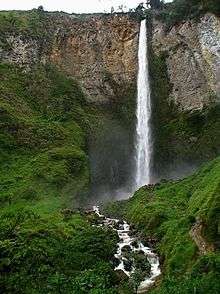 Sipisopiso waterfall drops from an opening on the rock face to the bottom | |
| Location | Tanah Karo Regency, North Sumatra, Indonesia |
| Coordinates | 2°54′59″N 98°31′11″E / 2.916416°N 98.519648°ECoordinates: 2°54′59″N 98°31′11″E / 2.916416°N 98.519648°E |
| Type | Plunge |
| Total height | 120 metres (390 ft) |
| Watercourse | Pajanabolon River |

The Sipisopiso is a plunge waterfall in the Batak highlands of Sumatra, Indonesia. It is formed by a small underground river of the Karo plateau that hurls itself from a cave in the side of the lake Toba caldera some 120 meters (360 feet) down to lake level. Sipisopiso is a well-known tourist attraction and a nearby vantage point offers great vistas of the fall and the lake.
Sipisopiso waterfall is located in the Tanah Karo regency in North Sumatra, at the northernmost tip of the Lake Toba caldera, near the fishing village of Tongging. The closest municipality, about 25 kilometers away, is the town of Kabanjahe.
This article is issued from
Wikipedia.
The text is licensed under Creative Commons - Attribution - Sharealike.
Additional terms may apply for the media files.