Simón Rodríguez Municipality, Táchira
| Simón Rodríguez Municipality Municipio Simón Rodríguez | |||
|---|---|---|---|
| Municipality | |||
| |||
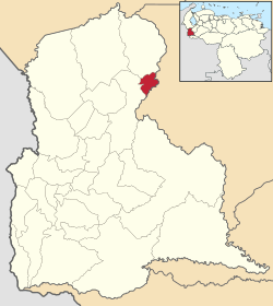 Location in Táchira | |||
.svg.png) Simón Rodríguez Municipality Location in Venezuela | |||
| Coordinates: 8°20′59″N 71°51′16″W / 8.34968°N 71.8544°WCoordinates: 8°20′59″N 71°51′16″W / 8.34968°N 71.8544°W | |||
| Country |
| ||
| State | Táchira | ||
| Municipal seat | San Simón[*] | ||
| Area | |||
| • Total | 69 km2 (27 sq mi) | ||
| Time zone | UTC−04:00 (VET) | ||
| Website | Official website | ||
Simón Rodríguez Municipality is one of the twenty-nine municipalities that composes the Táchira state in the Andes of Venezuela. Its capital is San Simón town. It has an extension of 69 km², according to estimations of National Institute of Statistic of Venezuela (NSI) its population for the year 2007 is of 3,000 inhabitants.
History
Its foundation dates from the year 1870 as the Valley of the Yeguines and Buruquias and was created as an autonomous municipality in the year of 1995.
Political and territorial division
Simón Rodríguez municipality have one parish denominated San Simón.
Limits
Limits to the north with the municipality of Samuel Darío Maldonado, to the south with Merida state, to the east with the Merida state and to the west with the municipality of Jáuregui.
References
This article is issued from
Wikipedia.
The text is licensed under Creative Commons - Attribution - Sharealike.
Additional terms may apply for the media files.