Silda, Sogn og Fjordane
 Silda Location in Sogn og Fjordane county | |
| Geography | |
|---|---|
| Location | Sogn og Fjordane, Norway |
| Coordinates | 62°00′46″N 5°11′21″E / 62.0127°N 5.1891°ECoordinates: 62°00′46″N 5°11′21″E / 62.0127°N 5.1891°E |
| Area | 1.1 km2 (0.42 sq mi) |
| Length | 1.5 km (0.93 mi) |
| Width | 1 km (0.6 mi) |
| Coastline | 7 km (4.3 mi) |
| Highest elevation | 98 m (322 ft) |
| Highest point | Vardehaugen |
| Administration | |
| County | Sogn og Fjordane |
| Municipality | Vågsøy Municipality |
| Demographics | |
| Population | 38 (2001) |
Silda is an island in Vågsøy Municipality in Sogn og Fjordane county, Norway. The 1.1-square-kilometre (0.42 sq mi) island is located 2 kilometres (1.2 mi) northeast of the large island of Vågsøy in the Sildagapet bay and about 2.5 kilometres (1.6 mi) west of the island of Barmøya. Silda sits about 2 kilometres (1.2 mi) east of the small village of Langenes and about 3 kilometres (1.9 mi) northeast of Raudeberg, both on the island of Vågsøy. This island is the site of the 1810 Battle of Silda. In 2001, there were 38 inhabitants on the island, which is only accessible by boat.[1]
Name
The name of the island comes from the Norwegian language word sild which means herring, since herring fishing has been important in the region for centuries.[2]
Media gallery
 Island of Silda
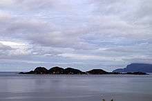 View of Silda
See also
References
- ↑ Statistisk sentralbyrå (2001). "Folke- og boligtellingen 2001, kommune- og bydelshefter 1439 Vågsøy" (PDF) (in Norwegian).
- ↑ Store norske leksikon. "Silda – øy i Nordfjord" (in Norwegian). Archived from the original on 2016-04-21. Retrieved 2010-07-20.
This article is issued from
Wikipedia.
The text is licensed under Creative Commons - Attribution - Sharealike.
Additional terms may apply for the media files.