Shot Tower Historical State Park
| Shot Tower State Park, Virginia, USA | |
|---|---|
 Shot Tower Historical State Park | |
 Location of Shot Tower State Park  Shot Tower State Park, Virginia, USA (the US) | |
| Location | 176 Orphanage Dr., Max Meadows, VA 24360 |
| Coordinates | 36°53′4″N 80°51′11″W / 36.88444°N 80.85306°WCoordinates: 36°53′4″N 80°51′11″W / 36.88444°N 80.85306°W |
| Area | 10 acres (4.0 ha) |
| Governing body | Virginia Department of Conservation and Recreation |
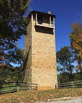
Shot Tower Historical State Park is a state park located near the town of Austinville, Virginia. Its centerpiece is the Jackson Ferry Shot Tower, located along the New River, which was for many years used for the creation of ammunition. The tower is listed on the National Register of Historic Places.
References
This article is issued from
Wikipedia.
The text is licensed under Creative Commons - Attribution - Sharealike.
Additional terms may apply for the media files.