Shaw Island
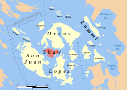 Location of Shaw Island in the San Juans | |
 Shaw | |
| Geography | |
|---|---|
| Location | Pacific Northwest |
| Coordinates | 48°34′24″N 122°57′26″W / 48.5732°N 122.9573°WCoordinates: 48°34′24″N 122°57′26″W / 48.5732°N 122.9573°W |
| Archipelago | San Juan Islands |
| Area | 7.7037 sq mi (19.952 km2) |
| Administration | |
|
United States | |
| State | Washington |
| County | San Juan County |
| Demographics | |
| Population | 240 (2010) |
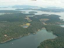
Shaw Island is the smallest of the four San Juan Islands served by the Washington State Ferries. The island has a land area of 19.952 square kilometres (7.704 square miles) and a small year-round population of 240 (2010 census). During the summer time, weekends swell with other residents and the occasional tourist. The Wilkes Expedition, in 1841, named the island after John Shaw, a United States Naval Officer.
Amenities, roads and public facilities
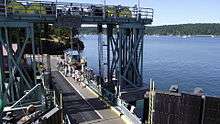
Shaw Island has a County park, a historic general store, and a post office at the ferry landing. A library and museum are located near the middle of the island.[1][2]
The University of Washington also owns property throughout the island, notably the Cedar Rock Reserve on the south side of the island. The stated vision for these properties are "to maintain and restore native biodiversity and ecosystem function and to facilitate education and research that is consistent with these goals" and "to maintain important parts of the cultural landscape."[3]
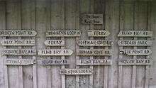
Shoreline access is best at the Shaw County Park, due to its vast beachline. There are 11.5 miles (18.5 km) of asphalt and 2.37 miles (3.81 km) of gravel public roads on Shaw. The primary roads are three loops in the interior of the island, with branches to the ferry dock, Shaw Island County Park, Neck Point, and Broken Point.
Tourism
Businesses pertaining to tourism are prohibited to maintain the character of the island as a small-scale, rural, and agricultural community through the Shaw Subarea Plan of Washington State's Growth Management Act. These include commercial recreational facilities; transient accommodations by themselves or in combination with any commercial use, food service facilities, and transient moorage and dry storage facilities.
Nuns
There have been three Catholic religious institutes of nuns on Shaw Island. Benedictine nuns established a monastery on 150 acres (61 hectares) in the 1970s; while the Sisters of Mercy have owned an unofficial retreat on the island since the 1980s.[4] Nuns of the Franciscan Sisters of the Eucharist ran the island's only store and the ferry terminal for almost 3 decades, until 2004, relocating elsewhere .[1]
Historical structures
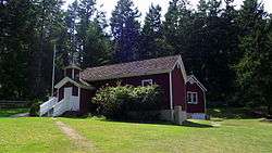
Shaw Island has an operational historic one-room school (although a second room was later added), with classes for elementary and middle school students. Known as the Little Red Schoolhouse, it has been in continuous use since it was built in 1890 and is the longest- running school in the state of Washington.[5] The building is listed on the U.S. National Register of Historic Places.[6]
Shaw Island also has a small library and historical museum.[2][6]
Popular culture
Shaw Island was featured during the fifth-season episode "Access" of the political drama The West Wing as the site of a standoff between terrorist suspects and the US government, similar to the Waco, Texas Branch Davidian standoff.
References
- 1 2 Oldham, Kit (12 October 2005). "Franciscan nuns depart Shaw Island after running the island ferry terminal and store for 27 years on June 2, 2004". Seattle, Washington: HistoryLink. Retrieved 30 December 2012.
- 1 2 "San Juan Islands Travel Region - Shaw Island". GoNorthwest.com. 30 November 2012. Retrieved 30 December 2012.
- ↑ "University of Washington San Juan Archipelago Biological Preserves". University of Washington. 21 November 2010. Retrieved 30 December 2012.
- ↑ Turner, Wallace (12 August 1987). "Sisters' Island Neighbors Uneasy". The New York Times. Retrieved 30 December 2012.
- ↑ "Shaw Island School - History". Shaw Island School District. Retrieved 30 December 2012.
- 1 2 Pitcher, Don (2012). San Juan Islands. Avalon Travel. p. 242.
External links
| Wikimedia Commons has media related to Shaw Island. |
- Official Guide to the San Juan Islands
- Non-profit island improvement organization
- Facts and pictures (pre-sale-of-store)
- Franciscan Sisters' Shaw Island page (pre-sale-of-store)
Municipalities and communities of San Juan County, Washington, United States | ||
|---|---|---|
| Populated islands | 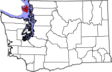 | |
| Town | ||
| Other communities | ||