Sennelager Training Area
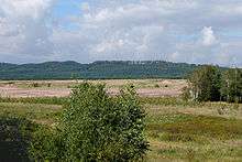
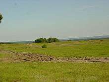
The Sennelager Training Area (German: Truppenübungsplatz Senne) is a military training area in Germany under the control of British Forces based in Paderborn Garrison. It covers an area of 116 square kilometres (45 sq mi) and belongs to the German Government which discharges its responsibility through the Institute for Federal Real Estate. The area was first used for military purposes at the end of the 19th century. The Field Marshal Rommel Barracks, Augustdorf is located nearby.
Location
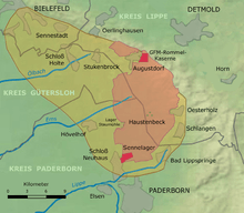
The training area lies north of Paderborn, on the western edge of the Teutoburg Forest in the middle of the Senne at a height of between 113 m and 382 m above NN. The Stapel Exercise Area in Lage, north of Augustdorf, also belongs to the Sennelager Training Area and covers some 550 hectares (1,400 acres). The land on which the training area is established falls within the boundaries of the following towns and villages: (clockwise beginning in the north): Augustdorf, Detmold, Schlangen (Lippe), Bad Lippspringe, Paderborn, Hövelhof (Paderborn district) and Schloß Holte-Stukenbrock (Gütersloh district).
Literature
References
External links

- Forces bases: Truppenübungsplatz Senne
- Paderborner Land Biological Station: Conservation on the Sennelager Training Area
- Out of bounds periods
Coordinates: 51°49′54″N 8°44′33″E / 51.831534°N 8.742371°E