Seibu-Kyūjō-mae Station
SI41 SY03 Seibu-Kyūjō-mae Station 西武球場前駅 | |
|---|---|
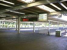
.JPG) Station entrance, June 2011 | |
| Location |
2090-3 Kamiyamaguchi, Tokorozawa-shi, Saitama-ken (埼玉県所沢市上山口2090-3) Japan |
| Operated by |
|
| Line(s) | |
| Platforms | 4 bay platforms |
| Connections |
|
| Other information | |
| Station code | SI41, SY03 |
| History | |
| Opened | 1929 |
| Previous names |
|
| Traffic | |
| Passengers (FY2014) | 10,669 daily |
Seibu-Kyūjō-mae Station (西武球場前駅 Seibu-Kyūjō-mae eki) is a railway station in Tokorozawa, Saitama, Japan, operated by the private railway operator Seibu Railway. It is located in front of the Seibu Dome, the home field of the Saitama Seibu Lions baseball team owned by Seibu Railway.
Lines
Seibu-Kyūjō-mae Station is the terminus of the 4.2 km Seibu Sayama Line from Nishi-Tokorozawa.[1] Some through services operate to and from Ikebukuro via the Seibu Ikebukuro Line. It is also the terminus of the 2.8 km Seibu Yamaguchi Line "Leo Liner" people mover which runs from Seibu-Yūenchi.
Station layout
The station consists of a three ground-level terminating platforms serving six tracks for the Sayama Line, and two more platforms for the Yamaguchi Line.[2] Platforms 3 to 6 are normally used only for additional services.[2]
Platforms
| 1-6 | ■ Seibu Sayama Line | for Nishi-Tokorozawa, Tokorozawa, and Ikebukuro |
| 7-8 | ■ Seibu Yamaguchi Line | for Seibu-Yūenchi |
Adjacent stations
| ← | Service | → | ||
|---|---|---|---|---|
| Seibu Sayama Line | ||||
| Shimo-Yamaguchi | Express | Terminus | ||
| Shimo-Yamaguchi | Rapid | Terminus | ||
| Shimo-Yamaguchi | Commuter semi express | Terminus | ||
| Shimo-Yamaguchi | Semi express | Terminus | ||
| Shimo-Yamaguchi | Local | Terminus | ||
| Seibu Yamaguchi Line | ||||
| Yūenchi-Nishi | - | Terminus | ||
History
The station opened on 1 May 1929, as Murayama-koen Station (村山公園駅).[1] This was renamed Murayama Chosuichi-giwa Station (村山貯水池際駅) on 1 March 1933, and Murayama Station (村山駅) on 1 April 1941.[1] Service was suspended from 28 February 1944, and the station reopened on 7 October 1951 as Sayamako Station (狭山湖駅).[1] It was renamed Seibu-Kyūjō-mae on 25 March 1979, following the opening of the Seibu baseball stadium nearby.[1]
Station numbering was introduced on all Seibu Railway lines during fiscal 2012, with Seibu-Kyūjō-mae Station becoming "SI41" on the Seibu Sayama Line and "SY03" on the Seibu Yamaguchi Line.[3]
Passenger statistics
In fiscal 2014, the station was used by an average of 10,669 passengers daily.[4]
The passenger figures for the station in previous years are as shown below.
| Fiscal year | Daily average |
|---|---|
| 2000 | 8,500[1] |
| 2009 | 8,565[5] |
| 2010 | 8,723[5] |
| 2011 | 9,356[6] |
Surrounding area
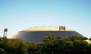
- Seibu Dome
- Sayama Ski Slope
- Murayama Reservoir
References
- 1 2 3 4 5 6 Terada, Hirokazu (July 2002). データブック日本の私鉄 [Databook: Japan's Private Railways]. Japan: Neko Publishing. p. 202. ISBN 4-87366-874-3.
- 1 2 Kawashima, Ryozo (February 2011). 日本の鉄道 中部ライン 全線・全駅・全配線 第11巻 埼玉南部・東京多摩北部 [Railways of Japan - Chubu Line - Lines/Stations/Track plans - Vol 11 Southern Saitama and Northern Tama Tokyo]. Japan: Kodansha. p. 12/77. ISBN 978-4-06-270071-9.
- ↑ 西武線全駅で駅ナンバリングを導入します [Station numbering to be introduced at all Seibu stations] (PDF). News Release (in Japanese). Japan: Seibu Railway. 23 February 2012. Archived from the original (pdf) on 2015-09-24. Retrieved 10 February 2013.
- ↑ 駅別乗降人員 2014(平成26)年度 1日平均 [Average daily station usage figures (fiscal 2011)] (PDF) (in Japanese). Japan: Seibu Railway. Archived from the original (PDF) on 8 March 2016. Retrieved 9 February 2016.
- 1 2 駅別乗降人員 2010(平成22)年度 1日平均 [Average daily station usage figures (fiscal 2010)] (PDF) (in Japanese). Japan: Seibu Railway. Archived from the original (PDF) on 26 June 2011. Retrieved 9 February 2013.
- ↑ 駅別乗降人員 2011(平成23)年度 1日平均 [Average daily station usage figures (fiscal 2011)] (PDF) (in Japanese). Japan: Seibu Railway. Archived from the original (PDF) on 1 November 2012. Retrieved 9 February 2013.
External links
| Wikimedia Commons has media related to Seibu-Kyūjō-mae Station. |
- Seibu-Kyūjō-mae Station information (Seibu) (in Japanese)
Coordinates: 35°46′15″N 139°25′11″E / 35.7707°N 139.4198°E