Saucillo Municipality
| Saucillo | ||
|---|---|---|
| Municipality | ||
| ||
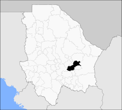 Municipality of Saucillo in Chihuahua | ||
|
Saucillo Location in Mexico | ||
| Coordinates: 28°02′N 105°17′W / 28.033°N 105.283°WCoordinates: 28°02′N 105°17′W / 28.033°N 105.283°W | ||
| Country |
| |
| State | Chihuahua | |
| Municipal seat | Saucillo | |
| Founded | November 27, 1896 | |
| Area | ||
| • Total | 2,116.16 km2 (817.05 sq mi) | |
| Population (2010) | ||
| • Total | 32,325 | |
| • Density | 15/km2 (40/sq mi) | |
Saucillo is one of the 67 municipalities of Chihuahua, in northern Mexico. The municipal seat lies at Saucillo. The municipality covers an area of 2,116.16 km².
As of 2010, the municipality had a total population of 32,325,[1] up from 28,508 as of 2005.[2]
As of 2010, the city of Saucillo had a population of 11,004.[1] Other than the city of Saucillo, the municipality had 451 localities, the largest of which (with 2010 populations in parentheses) were: Naica (4,938), Las Varas (2,410), classified as urban, and Estación Conchos (1,670), and Orranteño (1,641), classified as rural.[1]
Geography
Towns and villages
The municipality has 168 localities. The largest are:
| Name | Population (2005) |
|---|---|
| Saucillo | 9,261 |
| Naica | 4,775 |
| Las Varas | 2,355 |
| Conchos | 1,599 |
| Orranteño | 1,442 |
| Santa Gertrudis | 717 |
| Total Municipality | 28,508 |
References
- 1 2 3 "Saucillo". Catálogo de Localidades. Secretaría de Desarrollo Social (SEDESOL). Retrieved 23 April 2014.
- ↑ "Saucillo". Enciclopedia de los Municipios de México. Instituto Nacional para el Federalismo y el Desarrollo Municipal. Retrieved October 25, 2008.
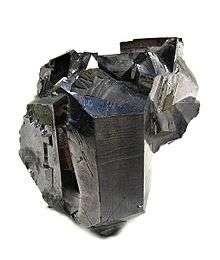
Galena crystal from the Naica Mine, Mexico's largest lead producer.
| Wikimedia Commons has media related to Saucillo, Chihuahua. |

This article is issued from
Wikipedia.
The text is licensed under Creative Commons - Attribution - Sharealike.
Additional terms may apply for the media files.