Sarygamysh Lake
| Sarygamysh Lake | |
|---|---|
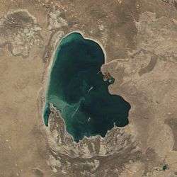 December 2001 | |
| Coordinates | 42°00′N 57°20′E / 42.000°N 57.333°ECoordinates: 42°00′N 57°20′E / 42.000°N 57.333°E |
| Basin countries | Turkmenistan, Uzbekistan |
| Max. length | 125 km (78 mi) |
| Max. width | 90 km (56 mi) |
| Surface area | 3,955 km2 (1,527 sq mi)[1] |
| Average depth | 8 m (26 ft) |
| Max. depth | 40 m (130 ft) |
| Water volume | 68.56 km3 (55,580,000 acre⋅ft)[1] |
| Surface elevation | 5 m (16 ft) |
The Sarygamysh Lake, also Sarykamysh or Sary-Kamysh (Turkmen: Sarygamyş köli, Uzbek: Sariqamish ko‘li, Russian: Сарыкамы́шское озеро), is a lake situated in Central Asia. It is geographically located approximately midway between the Caspian Sea and the Aral Sea. The northern quarter of the lake belongs to the country of Uzbekistan, while the rest belongs to Turkmenistan.
Up until the 17th century, Lake Sarygamysh was fed by the Uzboy River, a distributary of the Amu Darya River, which continued on to the Caspian Sea. Today, its main source of water is a canal from the Amu Darya but also the runoff water from surrounding irrigated lands, containing high levels of pesticides, herbicides and heavy metals.
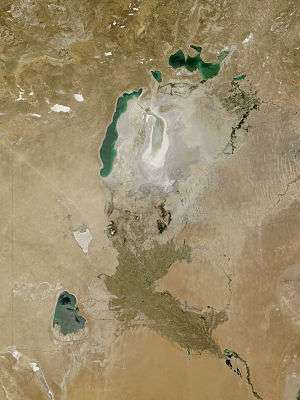
Contribution to the drying up of the Aral Sea

This and many other "unintended" lakes, such as Aydar Lake on the Syr Darya, created by the negligent Soviet planners, deny the Aral Sea about 150 cubic kilometers of annual inflow of water, directly contributing to, if not actually causing the latter's drying up.
Etymology
The name of the lake comes from Turkic Sari (yellow) and Qamish (depression), a reference to the yellow color of silt and salt in the old dried up basin before its flooding by the Soviets. The modern Turkmen authorities wish to "Turkmenize" the name by contending that the name is Turkmen sarykamysh 'yellow reed'.[2]
The Turkmen section of the lake and the land around it is protected by the Sarygamyş Sanctuary.
History

Throughout its history, the lake has disappeared several times and re-emerged, depending on the arrival of the Amudarya waters. The drying out periods of the Sarygamysh lake were associated with the confluence of the river into the Aral Sea. The lake existed at the end of the Neogene period, in the upper anthropogene[3] (at 58 m above sea level), when its area covered, including the modern Assake-Audan basin[4], and then in the 14th - 16th centuries AD (at the level of 50-62 metres above sea level).[3] The last time the waters of the Amu Darya directly entered the basin during the flood of 1878.[3][5]
Since the beginning of the 1960s, the Sarykamysh lake has been filled with collector-drainage waters[6] , feeding was carried out through the Daryalyk collector, while water from the farmland of the left bank of the Amu Darya was used.[6][7]
References
- 1 2 Orlovsky, Leah; Matsrafi, Offir; Orlovsky, Nikolai; Kouznetsov, Michael (2014). "Sarykamysh Lake: Collector of Drainage Water – The Past, the Present, and the Future". The Turkmen Lake Altyn Asyr and Water Resources in Turkmenistan. Berlin/Heidelberg: Springer-Verlag. doi:10.1007/698_2012_191.
- ↑ E.M. Pospelov, Geograficheskiye nazvaniya mira (Moscow, 1998), p. 369.
- 1 2 3 Сариқамиш сойлиги — Template:Книга:НЭУ
- ↑ http://bse.sci-lib.com/article076978.html Ассаке-Аудан
- ↑ Шнитников А. В. (1969). "Внутривековая изменчивость компонентов общей увлажненности". Ленинград: Издательство «Наука». Ленинградское отделение: 130.
- 1 2 Григорович Н. (1977). "Солнце и вода, земля и соль" (8) (Наука и жизнь ed.): 68–69.
- ↑ "Сары-Камыш" (Словарь современных географических названий ed.). Екатеринбург: У-Фактория. Под общей редакцией акад. В. М. Котлякова. 2006.
| Wikimedia Commons has media related to Sarygamysh Lake. |