Sarojahöhe
| Sarojahöhe | |
|---|---|
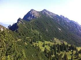 View from near the peak of Saroja of the Fürstensteig route going past Sattelspitz to Drei Schwestern with Gafleispitze in the distance. | |
| Highest point | |
| Elevation | 1,659 m (5,443 ft) |
| Coordinates | 47°11′27″N 9°34′21″E / 47.19083°N 9.57250°ECoordinates: 47°11′27″N 9°34′21″E / 47.19083°N 9.57250°E |
| Geography | |
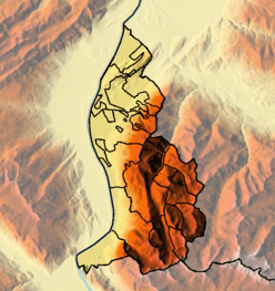 Sarojahöhe Location in Liechtenstein, on the border with Austria | |
| Location | Liechtenstein / Austria |
| Parent range | Rätikon, Alps |
Sarojahöhe or Saroja is a mountain on the border of Liechtenstein and Austria in the Rätikon range of the Eastern Alps to the east of the village of Planken, with a height of 1,659 metres (5,443 ft).
References
- Unfolding Liechtenstein, Panorama Map (Map). Liechtenstein Tourismus. 2007.
- Feldkirch - Vaduz (Map). 1:50000. Wander, Bike- und Skitourenkarte. Cartography by Kompass-Karten GmbH. Kompass. 2007.
This article is issued from
Wikipedia.
The text is licensed under Creative Commons - Attribution - Sharealike.
Additional terms may apply for the media files.