Sandy Run (Wissahickon Creek tributary)
| Sandy Run | |
|---|---|
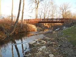 Sandy Run in Roslyn Park, Roslyn, Pennsylvania | |
| Country | United States of America |
| Physical characteristics | |
| Main source |
250 feet (76 m) 40°07′43″N 75°07′32″W / 40.128721°N 75.1254514°W[1] |
| River mouth |
148 feet (45 m)[1] 40°07′48″N 75°13′14″W / 40.1301097°N 75.2204546°WCoordinates: 40°07′48″N 75°13′14″W / 40.1301097°N 75.2204546°W[1] |
Sandy Run is a second-order stream (according to the Strahler stream order) that is a tributary to the Wissahickon Creek at Fort Washington State Park. The headwaters are in Dresher and Roslyn, Pennsylvania, and the stream flows west for approximately 6 miles (9.7 km). The stream follows through Abington, Upper Dublin, Springfield, and Whitemarsh Townships; and flows through several golf courses, including Sandy Run Country Club, Lu Lu Country Club, and Manufacturers Country Club. This creek can be fished in some places, mainly between Manufacturer's Country Club and the Wissahickon Creek. Fish that inhabit this creek include Sunfish, Carp, Smallmouth and Largemouth Bass, Catfish, and several other species.
Tributaries
No named tributaries
See also
References
- 1 2 3 "Sandy Run". Geographic Names Information System. United States Geological Survey. Retrieved 2009-01-26.
- Ambler 7.5 Minute Quadrangle, Department of the Interior, USGS.
| Wikimedia Commons has media related to Sandy Run (Wissahickon Creek). |
This article is issued from
Wikipedia.
The text is licensed under Creative Commons - Attribution - Sharealike.
Additional terms may apply for the media files.