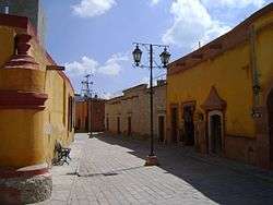
Bernal, Querétaro
| Bernal Ma'hando (Otomi) | |
|---|---|
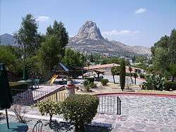
 Bernal and the Peña de Bernal | |
| Country |
|
| State | Querétaro |
| Municipality | Ezequiel Montes |
| Founded | 1647 |
| Population | |
| • Total | 2,909 |
| Time zone | UTC-6 (CST) |
San Sebastián Bernal (Otomi: Ma'hando), better known as Bernal (Spanish ![]()
Bernal is located 40 minutes by road from state capital Santiago de Querétaro and two and a half hours from Mexico City.[2] It is located in Ezequiel Montes municipality, a few minutes from Colón and Cadereyta.[2]
It has a current population of 2909. 1377 are males and 1532 are females. 1014 persons are counted as Economic Active Population and there are only 630 inhabited homes in town.[3]
It is known for its enormous monolith of massive rock, the Peña de Bernal, the third highest on the planet.[2]
Likewise, in the Otomi language: Ma'hando, in Chichimeca: De'hendo, has the same meaning: “In the middle of two”.[1]
Recently, the town of Bernal acquired the tourism quality labelPueblo Mágico ("Magical Town"). The Magical Towns are admitted for being localities that have magic symbolic attributes, legends, history, transcendental facts, that associate in each of his cultural manifestations, and that today mean a great opportunity for tourism.[2]
Climate
| Climate data for Bernal, Querétaro (1981-2010), extremes (1973-present) | |||||||||||||
|---|---|---|---|---|---|---|---|---|---|---|---|---|---|
| Month | Jan | Feb | Mar | Apr | May | Jun | Jul | Aug | Sep | Oct | Nov | Dec | Year |
| Record high °C (°F) | 30.0 (86) |
33.0 (91.4) |
40.0 (104) |
40.0 (104) |
38.0 (100.4) |
37.0 (98.6) |
35.0 (95) |
33.0 (91.4) |
33.0 (91.4) |
36.0 (96.8) |
32.0 (89.6) |
31.0 (87.8) |
40.0 (104) |
| Average high °C (°F) | 22.7 (72.9) |
24.5 (76.1) |
27.4 (81.3) |
29.7 (85.5) |
29.3 (84.7) |
27.3 (81.1) |
25.2 (77.4) |
25.7 (78.3) |
24.7 (76.5) |
24.3 (75.7) |
24.5 (76.1) |
23.0 (73.4) |
25.7 (78.3) |
| Daily mean °C (°F) | 13.4 (56.1) |
15.0 (59) |
17.6 (63.7) |
19.9 (67.8) |
20.2 (68.4) |
19.6 (67.3) |
18.3 (64.9) |
18.6 (65.5) |
18.0 (64.4) |
16.9 (62.4) |
15.6 (60.1) |
14.0 (57.2) |
17.3 (63.1) |
| Average low °C (°F) | 4.1 (39.4) |
5.4 (41.7) |
7.9 (46.2) |
10.2 (50.4) |
11.1 (52) |
12.0 (53.6) |
11.5 (52.7) |
11.4 (52.5) |
11.3 (52.3) |
9.4 (48.9) |
6.7 (44.1) |
5.0 (41) |
8.8 (47.8) |
| Record low °C (°F) | −9.0 (15.8) |
−6.0 (21.2) |
−2.0 (28.4) |
2.0 (35.6) |
4.0 (39.2) |
6.0 (42.8) |
1.0 (33.8) |
0.5 (32.9) |
4.0 (39.2) |
−4.0 (24.8) |
−5.0 (23) |
−8.0 (17.6) |
−9.0 (15.8) |
| Average precipitation mm (inches) | 10.0 (0.394) |
6.0 (0.236) |
11.8 (0.465) |
25.1 (0.988) |
39.4 (1.551) |
70.8 (2.787) |
94.2 (3.709) |
80.6 (3.173) |
72.1 (2.839) |
41.5 (1.634) |
11.9 (0.469) |
2.1 (0.083) |
465.5 (18.327) |
| Average precipitation days (≥ 0.1 mm) | 1.6 | 1.3 | 1.6 | 2.7 | 5.1 | 7.1 | 7.9 | 7.2 | 8.1 | 4.4 | 1.5 | 0.8 | 49.3 |
| Source: Servicio Meteorológico Nacional (temperature, 1981-2010) [4] | |||||||||||||
References
- 1 2 "querétaro-méxico". Ezequiel Montes Querétaro. Archived from the original on 2008-01-29. Retrieved 2008-01-28.
- 1 2 3 4 "de-paseo". Bernal Pueblo Mágico. Retrieved 2008-01-28.
- ↑ "INEGI". Archived from the original on 2007-08-24. Retrieved 2008-01-28.
- ↑ "Extreme Temperatures and Precipitation for Bernal 1981-2010" (in Spanish). Servicio Meteorológico Nacional. Retrieved 7 May 2017.
See also
Coordinates: 20°44′20″N 99°56′24″W / 20.73889°N 99.94000°W
| Wikimedia Commons has media related to Bernal, Querétaro. |