San Juan La Laguna
| San Juan La Laguna Xe' Kuku' Juyu' | |
|---|---|
| Municipality and town | |
 San Juan La Laguna | |
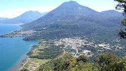
 San Juan La Laguna location in Guatemala | |
| Coordinates: 14°42′N 91°17′W / 14.700°N 91.283°WCoordinates: 14°42′N 91°17′W / 14.700°N 91.283°W | |
| Country |
|
| Department |
|
| Government | |
| • Type | municipal |
| • Mayor | Antonio Chavajay Ixtamer |
| Area | |
| • Total | 3,718 km2 (1,436 sq mi) |
| Lowest elevation | 1,562 m (5,125 ft) |
| Population (2002) | |
| • Total | 10,177 |
| • Density | 27,372/km2 (70,890/sq mi) |
| Time zone | UTC-6 (Central Time) |
| Postal code | 07017 |
| Country calling code | 502 |
| Climate | Aw |
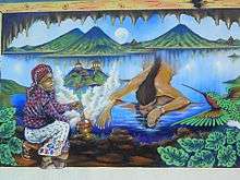
Mural depicting Tz'utujil Mayan creation legend
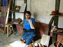
Tz'utujil women demonstrates traditional weaving techniques
San Juan La Laguna (Spanish pronunciation: [saŋ ˈxwan la laˈɣuna]) is a municipality on the southern shore of Lago de Atitlán, Sololá, Guatemala. It consists of the village named San Juan La Laguna and three smaller aldeas (small villages) in the nearby mountain. The population is approximately 95% Tz'utujil. Agriculture is most important for the economy, with the service sector growing, especially as the number of tourists increase. The lowest elevation is the shore of Lago Atitlán at 1,562 metres (5,125 ft).
References
| Wikimedia Commons has media related to San Juan La Laguna. |

This article is issued from
Wikipedia.
The text is licensed under Creative Commons - Attribution - Sharealike.
Additional terms may apply for the media files.