Sainte-Anne-des-Monts, Quebec
| Sainte-Anne-des-Monts | |
|---|---|
| City | |
 | |
|
Motto(s): Per crucem ad lumen ("By the Cross Towards the Light") | |
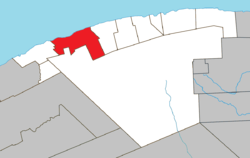 Location within La Haute-Gaspésie RCM. | |
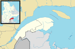 Sainte-Anne-des-Monts Location in eastern Quebec. | |
| Coordinates: 49°08′N 66°30′W / 49.133°N 66.500°WCoordinates: 49°08′N 66°30′W / 49.133°N 66.500°W[1] | |
| Country |
|
| Province |
|
| Region | Gaspésie–Îles-de-la-Madeleine |
| RCM | La Haute-Gaspésie |
| Settled | 1815 |
| Constituted | February 2, 2000 |
| Government[2] | |
| • Mayor | Simon Deschênes |
| • Federal riding | Gaspésie—Les Îles-de-la-Madeleine |
| • Prov. riding | Gaspé |
| Area[2][3] | |
| • Total | 336.40 km2 (129.88 sq mi) |
| • Land | 263.31 km2 (101.66 sq mi) |
| Elevation[4] | 15.20 m (49.87 ft) |
| Population (2011)[3] | |
| • Total | 6,933 |
| • Density | 26.3/km2 (68/sq mi) |
| • Pop 2006-2011 |
|
| • Dwellings | 3,323 |
| Time zone | UTC−5 (EST) |
| • Summer (DST) | UTC−4 (EDT) |
| Postal code(s) | G4V |
| Area code(s) | 418 and 581 |
| Highways |
|
| Website |
www.villesainte- anne-des-monts.qc.ca |
Sainte-Anne-des-Monts (French pronunciation: [sɛ̃t an de mɔ̃]) is a city in the Gaspésie–Îles-de-la-Madeleine region of the province of Quebec in Canada.
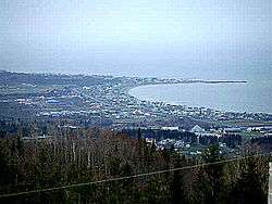
Sainte-Anne-des-Monts, a small city between the Chic-Choc Mountains and sea, it is on the south shore of the St-Lawrence river estuary. In addition to Sainte-Anne-des-Monts itself, the town's territory also includes the communities of L'Anse-de-l'Église, L'Anse-Sainte-Anne-des-Monts, Mont-Albert, Petit-Tourelle, Ruisseau-à-Patates, and Tourelle.
History
The name of Notre-Dame has appeared on schematic maps since 1709. The official nomenclature came from the seigniorial of Sainte-Anne-des-Monts conceded to Denis Riverin in 1688. The first settlers arrived in 1815 and established small fisheries. The place was incorporated as a municipality in 1855. The city was the center of pilgrimage at the beginning of the twentieth century. The City was partially destroyed by fire in 1915.[1]
In 1968, Sainte-Anne-des-Monts gained city status. On February 2, 2000, the City of Sainte-Anne-des-Monts and the Municipality of Tourelle were merged to form the new City of Sainte-Anne-des-Monts–Tourelle. It was renamed to its current name on February 10, 2001.[1]
Economy
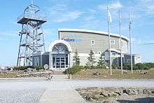
Tourism and fishing are the local industries. Exploramer, is an activity complex on the Saint-Lawrence River aquatic fauna, where you can see an aquarium offering 21 tanks which contain fish, marine organism, a thematic exhibition about the sea, offshore excursions, and many more cultural events.
On the other side the mountains, the National Park of Gaspésie opens the door to the McGerrigle and Chic-Chocs mountains. They offer a panoramic photographic opportunity for the apex of Mont-Jacques-Cartier, second highest summit in Québec.
Demographics
Population
| Canada census – Sainte-Anne-des-Monts, Quebec community profile | |||
|---|---|---|---|
| 2011 | 2006 | ||
| Population: | 6,933 (+2.4% from 2006) | 6,772 (-0.9% from 2001) | |
| Land area: | 263.31 km2 (101.66 sq mi) | 263.31 km2 (101.66 sq mi) | |
| Population density: | 26.3/km2 (68/sq mi) | 25.7/km2 (67/sq mi) | |
| Median age: | 49.1 (M: 48.7, F: 49.4) | 45.8 (M: 45.4, F: 46.3) | |
| Total private dwellings: | 3,323 | 3,068 | |
| Median household income: | $38,770 | $31,915 | |
| Notes: City of Sainte-Anne-des-Monts and the Municipality of Tourelle merged on February 2, 2000. – References: 2011[3] 2006[5] earlier[6] | |||
| Historical Census Data - Sainte-Anne-des-Monts, Quebec[7] | |||||||||||||||||||||||||||||
|---|---|---|---|---|---|---|---|---|---|---|---|---|---|---|---|---|---|---|---|---|---|---|---|---|---|---|---|---|---|
|
|
| |||||||||||||||||||||||||||
(M) City of Sainte-Anne-des-Monts and the Municipality of Tourelle merged on February 2, 2000. | |||||||||||||||||||||||||||||
Language
Mother tongue:[8]
- English as first language: 0.1%
- French as first language: 98.6%
- English and French as first language: 0%
- Other as first language: 1.3%
Tourism
Sainte-Anne-des-Monts is the access point to Gaspésie National Park and the Chic-Choc Mountains. A common activity is to explore the forest and mountains by snowshoe, snowmobile or walking.
This area is visited by natural sites enthusiasts, as cross-country skiing, Telemark skiing, walking, horse riding, paragliding, sea kayaking, fishing in the river and snowmobiling give access to marked paths touring the Gaspésie area. Both moose and caribou (the last herd south of the Saint Lawrence River) are found in the park.
A new activity has also arisen in Gaspésie. Known as D'Arbre en Arbre (tree to tree) it an adventure at the top of trees.
Transportation
The municipality is located along Quebec Route 132, which follows the coast of the Gaspé Peninsula. Quebec Route 299, locally called the Park Route, links Sainte-Anne-des-Monts to New Richmond, by taking a smooth and yet outstanding panoramic route through the boroughs. The same route also gives access to the Gaspésie National Park.
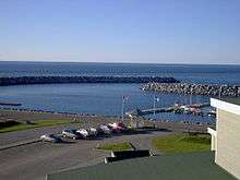
The federal government manages a wharf with a pier for pleasure boats. The Sainte-Anne-des-Monts Aerodrome, with an asphalt runway, can be found in the outskirts of the municipality. Transport by rail is not available.
Sainte-Anne-des-Monts is the center of collective transportation and para-transit for the Haute-Gaspésie area.
Services
Because of its size, the municipality is a cluster for a scattered population. There is a hospital, a CLSC, one high school, a police station, a Justice Hall, a cultural center and an auditorium, libraries and several government offices servicing the area in regards to fishing and fauna. A college (CÉGEP) is located in Matane, only 90 kilometres (56 mi) from Sainte-Anne-des-Monts.
The municipality is the access point to the Parc de la Gaspésie, where one can find a hotel, motels and restaurants. Popular chain restaurants and chain convenience store can be found such as Tim Hortons, Subway and Couche-Tard. There are two large surface grocery stores and gasoline stations.
Climate
| Climate data for Sainte-Anne-des-Monts | |||||||||||||
|---|---|---|---|---|---|---|---|---|---|---|---|---|---|
| Month | Jan | Feb | Mar | Apr | May | Jun | Jul | Aug | Sep | Oct | Nov | Dec | Year |
| Record high °C (°F) | 15 (59) |
15 (59) |
17 (63) |
27 (81) |
28 (82) |
33.3 (91.9) |
31.1 (88) |
31.7 (89.1) |
33 (91) |
26.1 (79) |
20.5 (68.9) |
16.1 (61) |
33.3 (91.9) |
| Average high °C (°F) | −7.4 (18.7) |
−6.3 (20.7) |
−0.9 (30.4) |
5 (41) |
11.9 (53.4) |
18 (64) |
20.8 (69.4) |
19.7 (67.5) |
15 (59) |
9.1 (48.4) |
2.3 (36.1) |
−3.8 (25.2) |
6.9 (44.4) |
| Daily mean °C (°F) | −11.7 (10.9) |
−10.6 (12.9) |
−5 (23) |
1.3 (34.3) |
7.5 (45.5) |
13.4 (56.1) |
16.6 (61.9) |
15.5 (59.9) |
11 (52) |
5.4 (41.7) |
−0.6 (30.9) |
−7.4 (18.7) |
2.9 (37.2) |
| Average low °C (°F) | −16 (3) |
−14.8 (5.4) |
−9.2 (15.4) |
−2.3 (27.9) |
3 (37) |
8.6 (47.5) |
12.3 (54.1) |
11.2 (52.2) |
6.9 (44.4) |
1.8 (35.2) |
−3.5 (25.7) |
−10.9 (12.4) |
−1.1 (30) |
| Record low °C (°F) | −33 (−27) |
−28.9 (−20) |
−28.3 (−18.9) |
−20 (−4) |
−8.9 (16) |
−1.7 (28.9) |
2.2 (36) |
1.1 (34) |
−2.8 (27) |
−11.1 (12) |
−15.6 (3.9) |
−27.2 (−17) |
−33 (−27) |
| Average precipitation mm (inches) | 57.1 (2.248) |
43.9 (1.728) |
57.6 (2.268) |
55.6 (2.189) |
68.4 (2.693) |
73.7 (2.902) |
93.3 (3.673) |
83.3 (3.28) |
84 (3.31) |
83.7 (3.295) |
75.4 (2.969) |
68.7 (2.705) |
844.6 (33.252) |
| Average rainfall mm (inches) | 7.7 (0.303) |
4.6 (0.181) |
11.2 (0.441) |
36.4 (1.433) |
67.5 (2.657) |
73.7 (2.902) |
93.3 (3.673) |
83.3 (3.28) |
84 (3.31) |
82.1 (3.232) |
45.6 (1.795) |
16.1 (0.634) |
605.4 (23.835) |
| Average snowfall cm (inches) | 49.3 (19.41) |
39.3 (15.47) |
46.4 (18.27) |
19.2 (7.56) |
0.9 (0.35) |
0 (0) |
0 (0) |
0 (0) |
0 (0) |
1.6 (0.63) |
29.8 (11.73) |
52.6 (20.71) |
239.1 (94.13) |
| Source: Environment Canada[4] | |||||||||||||
See also
References
- 1 2 3 "Sainte-Anne-des-Monts (Ville)" (in French). Commission de toponymie du Québec. Retrieved 2011-12-19.
- 1 2 "Sainte-Anne-des-Monts". Répertoire des municipalités (in French). Ministère des Affaires municipales, des Régions et de l'Occupation du territoire. Retrieved 2011-12-19.
- 1 2 3 "2011 Community Profiles". Canada 2011 Census. Statistics Canada. July 5, 2013. Retrieved 2014-01-29.
- 1 2 Environment Canada, Canadian Climate Normals 1971–2000, accessed 7 August 2012
- ↑ "2006 Community Profiles". Canada 2006 Census. Statistics Canada. March 30, 2011. Retrieved 2011-12-19.
- ↑ "2001 Community Profiles". Canada 2001 Census. Statistics Canada. February 17, 2012.
- ↑ Statistics Canada: 1996, 2001, 2006, 2011 census
- ↑ "Sainte-Anne-des-Monts community profile". 2006 Census data. Statistics Canada. Retrieved 2011-12-19.
External links
| Wikimedia Commons has media related to Sainte-Anne-des-Monts. |
- Répertoire des municipalités du Québec
- Commission de toponymie du Québec
- Affaires municipales et régions - cartes régionales
Adjacent Municipal Subdivisions | ||||||||||
|---|---|---|---|---|---|---|---|---|---|---|
| ||||||||||
| Cities | |
|---|---|
| Municipalities | |
| Villages | |
| Unorganized Territories | |
| |