Saint Peter and Saint Paul Archipelago
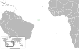
The Saint Peter and Saint Paul Archipelago (Portuguese: Arquipélago de São Pedro e São Paulo [ɐʁkiˈpɛlɐgu dʒi sɐ̃w ˈpedɾw‿i sɐ̃w ˈpawlu]) is a group of 15 small islets and rocks in the central equatorial Atlantic Ocean.[3] It lies in the Intertropical Convergence Zone, a region of the Atlantic characterized by low average winds punctuated with local thunderstorms. It lies approximately 510 nmi (940 km; 590 mi) from the nearest point of mainland South America (the northeastern Brazilian coastal town of Touros); 625 km (388 mi) northeast of the archipelago of Fernando de Noronha; 990 km (620 mi) from the city of Natal; and 1,824 km (1,133 mi) from the west coast of Africa. Administratively, the archipelago belongs to Brazil and is part of the special "state district" (Portuguese: distrito estadual) of Fernando de Noronha, in the state of Pernambuco, in spite of the very large distance between the two island groups and the even larger distance to the state mainland.
The islets expose serpentinized abyssal mantle peridotite and kaersutite-bearing ultramafic mylonite atop the world's highest and yet only second largest megamullion (after the Parece Vela megamullion under Okinotorishima in the Pacific Ocean). This grouping is the sole location in the Atlantic Ocean where the abyssal mantle is exposed above sea level.[4]
In 1986, the archipelago was designated an environmentally protected area.[5] This is now part of the Fernando de Noronha Environmental Protection Area.[6] Since 1998, the Brazilian Navy has maintained a permanently manned research facility on the islands.[2] The main economic activity around the islets is tuna fishing.
History
On April 20, 1511, a Portuguese Navy fleet composed of six caravels under the command of Captain Garcia de Noronha discovered the islets by accident while on their journey to India. While navigating in open sea at late night, the Saint Peter caravel, under the command of Captain Manuel de Castro Alcoforado, crashed against the islets. The crew was rescued by the Saint Paul caravel, forming the name given to the islets.[4]
On the morning of February 16, 1832, the rocks were visited by Charles Darwin on the first leg of his voyage on HMS Beagle around the world. Darwin listed all the fauna he could find; noting that not a single plant or even a lichen could be found on the island. Darwin found two birds, a booby and a noddy, a large crab that stole the fish intended for baby birds, a fly that lived on the booby and a parasitic tick. He found a moth that lived on feathers, a beetle, a woodlouse that lived on dung, and numerous spiders that he thought lived on scavengers of the waterfowl. Darwin felt that these rocks represented how life first took hold on a newly formed outcrop.[7] Darwin was correct in noting that, unusually, these small islands were not volcanic, but were instead formed by a geologic uplift.[4] Darwin's account formed the basis of a fictionalized episode in Patrick O'Brian's historical novel HMS Surprise, when the naturalist Stephen Maturin is briefly marooned and survives by drinking fouled rainwater and the blood of boobies.[8]
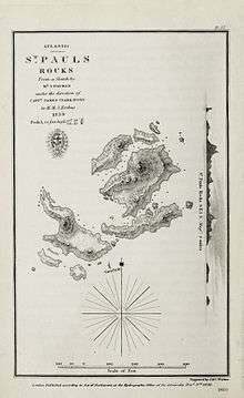
The then called “St. Paul's Rocks” were visited by James Clark Ross on 29 November 1839. He was in charge of an expedition to the Antarctic regions with two vessels, HMS Erebus and HMS Terror. Robert McCormick gave some geological and biological remarks on St. Paul's Rocks in the report on the expedition.[9]
Another famous person to visit the rocks was Ernest Shackleton, on his last expedition to Antarctica (1921–1922).[4]
In 1942, during World War II, the islets were declared to be part of the Federal Territory of Fernando de Noronha (which also included the Rocas Atoll).
In early 1960, the rocks served as the starting-point and terminus for the first submerged circumnavigation of the world by the American nuclear-powered submarine USS Triton.[10]
Scientific station
On June 25, 1998, the Brazilian Navy inaugurated the Saint Peter and Saint Paul Archipelago Scientific Station (Portuguese: Estação Científica do Arquipélago de São Pedro e São Paulo; ECASPSP). The station is manned with four researchers, who are rotated in and out every 15 days.[11] By maintaining permanent occupation of the archipelago, the Brazilian Navy extends Brazil's Exclusive Economic Zone, territorial waters and airspace into the North Atlantic Ocean.[12]
On June 5–6, 2006, an earthquake with a magnitude of above six on the Richter magnitude scale rocked the archipelago. The strong tidal surge following the earthquake caused the battery compartment to crash against the station's outer wall, allowing sea water to flood the station. The four researchers who were on the archipelago took shelter in the lighthouse, while maintaining constant contact with the Brazilian Navy. A fishing vessel located nearby rescued the researchers, who were then transferred to a Brazilian Navy patrol boat. The incident caused considerable damage to the station and equipment.[13] The station was repaired on September 9–11, 2006, and became operational shortly after.[14]
In 2007, the Brazilian Navy started to build a new scientific station on the archipelago.[11] Construction began on July 24, 2007, and was completed on June 25, 2008.[11] The new station was built with seismic isolation, and is considerably larger and better equipped than the previous one.[15] The station is composed of a main building - equipped with reverse osmosis salt water desalination system, photovoltaics system and satellite communications system; deposits and a mooring dock.[3][16]
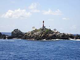
The Brazilian Navy also maintains a lighthouse on the archipelago, (ARLHS: SPP-001), built in 1995 to replace a previous one from 1930.[4][17]
Air France Flight 447
On June 1, 2009, Air France Flight 447, an Airbus A330-200 jetliner en route from Rio de Janeiro to Paris with 228 persons on board crashed on the Atlantic Ocean relatively close to the Saint Peter and Saint Paul Archipelago, killing all its occupants. Bodies and fragments from the aircraft were found near the archipelago.[18]
Geography
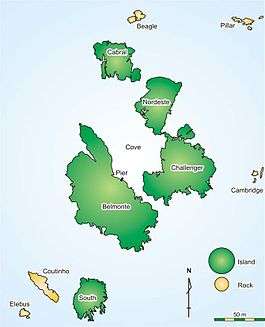
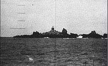
The Saint Peter and Saint Paul Rocks are situated in the Atlantic Ocean, 100 km (62 mi) north of the Equator and are the only group of Brazilian oceanic islets in the Northern Hemisphere. The nearest point in the Brazilian coast, is Cabo do Calcanhar, Rio Grande do Norte, approximately 1,010 kilometres (630 mi) from the archipelago. The total emerged area is about 4.2 acres (1.7 ha) and the maximum land elevation is 18 m (59 ft), on Nordeste Island. The archipelago is composed of several rocks, five small rocky islets and four larger islets:[4][19]
- Belmonte Islet: 5,380 square metres (57,900 sq ft)
- Challenger Islet (also known as São Paulo): 3,000 square metres (32,000 sq ft)
- Nordeste Islet (also known as São Pedro): 1,440 square metres (15,500 sq ft)
- Cabral Islet: 1,170 square metres (12,600 sq ft)
- South Islet: 943 square metres (10,150 sq ft).
Their base is over 3,650 metres (11,980 ft) below sea level.[4]
None of the islets has a permanent fresh water supply available.[4]
Biology
Only the largest of the islets, Belmonte, is vegetated with mosses and grasses. The other rocks are mostly barren, except for some sea algae and fungi that can tolerate the salt spray. The rocks are inhabited by seabirds, including the brown booby (Sula leucogaster), brown noddy (Anous stolidus), and black noddy (Anous minutus), as well as crabs (Grapsus grapsus), insects and spiders.[20]
References
- 1 2 3 The Scientific Station of São Pedro and São Paulo Archipelago Alvarez, Cristina; Melo, Julio; Mello, Roberto L. Retrieved on 2009-07-14.
- 1 2 Programa Arquipélago Brazilian Navy. Retrieved on 2009-07-16. (in Portuguese)
- 1 2 The scientific station of São Pedro and São Paulo Archipelago - Brazil Alvarez, Cristina E., Melo, Julio E., Mello, Roberto L. Retrieved on June 6, 2009.
- 1 2 3 4 5 6 7 8 Saint Peter and Saint Paul’s Archipelago - Tectonic uplift of infracrustal rocks in the Atlantic Ocean Campos, T.F.C.; Virgens Neto, J.; Srivastava, N.K.; Petta, R.A.; Harmann, L.A.; Moraes, J.F.S.; Mendes, L.; Silveira, S.R.M. In: Winge, M.; Schobbenhaus, C.; Berbert-Born, M.; Queiroz, E.T.; Campos, D.A.; Souza, C.R.G.; Fernandes, A.C.S. (Ed.), Geological and Palaeontological Sites of Brazil. Retrieved on 2017-03-20.
- ↑ Decree 92755 of 5 June 1986 Archived 17 February 2012 at the Wayback Machine. Library of Congress. Retrieved on 2009-07-16.
- ↑ Área de Proteção Ambiental Fernando de Noronha – Rocas – São Pedro e São Paulo (in Portuguese), Parque Nacional Marinho Fernando de Noronha, archived from the original on 2017-01-04, retrieved 2016-04-21
- ↑ Darwin's description from Voyage of the Beagle Retrieved on 2009-07-16.
- ↑
- O'Brian, Patrick: H.M.S. Surprise, W.W. Norton & Company, New York, 1973, Chapter 5, p. 117.
- ↑ Ross (1847), pp. 15-17, vol.1.
- ↑ Beach, Edward L. (1962). Around the world submerged: the voyage of the Triton. New York: Holt, Rinehart and Winston. pp. 102–105, 257. ISBN 1-55750-215-3. OCLC 1292457.
- 1 2 3 Nova Era no Arquipélago de São Pedro e São Paulo Archived 2011-09-27 at the Wayback Machine. Brazilian Navy. Retrieved on June 6, 2009.
- ↑ Lançamento da nova Estação Científica do Arquipélago de São Pedro e São Paulo Archived 2009-12-01 at the Wayback Machine. Brazilian Navy. Retrieved on June 6, 2009.
- ↑ Acidente no Arquipélago de São Pedro e São Paulo Brazilian Navy. Retrieved on 2009-07-16. (in Portuguese)
- ↑ Recuperação da Estação Científica do Arquipélago de São Pedro e São Paulo (ECASPSP) Brazilian Navy. Retrieved on 2009-07-16. (in Portuguese).
- ↑ A construção da nova Estação Científica Brazilian Navy. Retrieved on 2009-07-16. (in Portuguese)
- ↑ Manual do Pesquisador Archived 2011-09-27 at the Wayback Machine. Brazilian Navy. Retrieved on 2009-07-16. (in Portuguese)
- ↑ "ARLHS: SPP-001". ARLHS. 2006-06-01. Retrieved 2009-06-07.
- ↑ "Total of 41 bodies recovered from Air France 447 crash". CNN.com. 2009-06-09. Retrieved 2017-06-03.
- ↑ Feitoza, Bertran M; Rocha, Luiz A.; Luiz-Junior, Osmar J.; Floeter, Sergio R.; Gasparini, Joao L. (May 2003). "Reef fishes of St. Paul's Rocks: new records and notes on biology and zoogeography" (PDF). Aqua, Journal of Ichthyology and Aquatic Biology. 7 (3): 1–22. Retrieved 2009-06-03.
- ↑ Série de reportagens sobre o arquipélago de São Pedro e São Paulo e as ilhas de Trindade e Martim Vaz Archived 2009-12-01 at the Wayback Machine. O Globo. Retrieved on 2009-07-16. (in Portuguese)
Further reading
- Andrade, F.G.G., Simões, L.S.A., Campos, T.F.C., Silva, A.J.C.A. 2007. Padrão estrutural da foliação milonígica do Arquipélago de São Pedro e São Paulo. Anais do 11º Simpósio Nacional de Estudos Tectônicos, 5th International Symposium of Tectonics of the SBG. Natal, 233. (in Portuguese)
- Beach, Edward L. November 1960 (Vol. 118, No. 5). "Triton Follows Magellan's Wake" National Geographic Magazine. 585-615
- Bonatti, E. 1990. Subcontinental mantle exposed in the Atlantic Ocean on St Peter-Paul islets. Nature, 345, 800-802.
- Campos, T.F.C., Virgens Neto, J., Amorim, V.A., Hartmann, L.A., Petta, R.A. 2003. Modificações metassomáticas das rochas milonitizadas do complexo ultramáfico do Arquipélago de São Pedro e São Paulo, Atlântico Equatorial. Geochimica Brasiliensis, 17-2, 81-90. (in Portuguese)
- Campos, T.F.C., Virgens Neto, J., Costa, L.S., Petta, R.A., Sousa, L.C., Silva, F.O. 2007. Sistema de diaclasamento do Arquipélago de São Pedro e São Paulo (Atlântico Equatorial) como indicador de movimentação destral associado à falha transformante de São Paulo. Anais do 11º Simpósio Nacional de Estudos Tectônicos, 5th International Symposium of Tectonics of the SBG. Natal, 238. (in Portuguese)
- Hékinian, R., Juteau, T., Gracia, E., Udintsev, G., Sichler, B., Sichel, S.E., Apprioual, R. 2000. Submersible observations of Equatorial Atlantic Mantle: The St. Paul Frature Zone region. Marine Geophysical Research, 21, 529-560.
- Melson, W.G., Jarosewich, E., Bowen, V.T., Thompsonm G. 1967. St. Peter and St. Paul rocks: a high-temperature mentle-derived intrusion. Science, 155. 1532-1535.
- Moraes, J.F.S., Linden, E.M., Moraes, F.A.B. 1997. Planta topográfica do Arquipélago de São Pedro e São Paulo, escala 1:500. CPRM - Serviço Geológico do Brasil.
- Motoki, A., Sichel, S.E., Campos, T.F.C., Srivastava, N.K., Soares, R.S. 2009. Taxa de soerguimento atual do Arquipélago de São Pedro e São Paulo, Oceano Atlântico Equatorial. Revista Escola de Minas, 62-3. 331-342. (in Portuguese)
- Ross, James Ross (1847).

- Sichel, S.E., Esperança, S., Motoki, A., Maia, M., Horan, M.F., Szatmari, P., Alves, E.C., Mello, S.L.M. 2008. Geophysical and geochemical evidence for cold upper mantle beneath the Equatorial Atlantic Ocean. Revista Brasileira de Geofísica, 26-1, 69-86.
- Souza, José Eduardo Borges de: O arquipélago de São Pedro e São Paulo, Rio de Janeiro, Revista do Clube Naval, Ano 115, N° 340, Out/Nov/Dez 2006. p. 70-72, ISSN 0102-0382.
- Thompson, Geoffrey: St. Peter and St. Paul's Rocks (Equatorial Atlantic) and the Surrounding Sea Floor, Woods Hole, Woods Hole Oceanographic Institution, 1981 (Technical Report) (Woods Hole Oceanog. Inst. Tech. Rept. WHOI-81 -98)
- Tressler, Willis L.: Rochedos São Pedro e São Paulo (St. Peter and St. Paul Rocks), Washington, U. S. Navy Hydrographic Office, 1956 (Technical Report, TR-31).
- Virgens Neto, J., Campos, T.F.C. 2007. A influência da zona de fratura São Paulo no contexto estrutural do Arquipélago de São Pedro e São Paulo - Atlântico Equatorial. Anais do 11º. Simpósio Nacional de Estudos Tectônicos, 5th International Symposium of Tectonics of the SBG. Natal, 294-295. (in Portuguese)
- Wiseman, J. D. H. 1966. St Paul's Rocks and the Problem of the Upper Mantle. Geophysical Journal of the Royal Astronomical Society, 11, 519-525. (in Portuguese)
External links
| Wikimedia Commons has media related to Category:São Pedro e São Paulo. |
| Wikisource has the text of the 1911 Encyclopædia Britannica article St Paul's Rocks. |
- Official website (in Portuguese)
- A New Era on the Archipelago of Saint Peter and Saint Paul Brazilian Navy publication
- "St. Peter and St. Paul rocks". Terrestrial Ecoregions. World Wildlife Fund.
- Information and pictures from landing, February 2001
- Darwin's description from Voyage of the Beagle
- First Visit of Brazilian Research Vessel
- Penedos de Sao Pedro e São Paulo (Spanish)