Florida State Road 501
| ||||
|---|---|---|---|---|
| Clearlake Road | ||||
| Route information | ||||
| Maintained by FDOT | ||||
| Length | 3.358 mi[1] (5.404 km) | |||
| Major junctions | ||||
| South end |
| |||
| North end |
| |||
| Highway system | ||||
| ||||

Locally known as Clearlake Road, State Road 501 is a three-mile (5 km) long north–south highway entirely within Cocoa, Florida, in the United States. It southern terminus is an intersection with King Street (SR 520); its northern terminus is an intersection with SR 524 just south of an interchange with State Road 528 and Grissom Parkway. Until the mid-1980s, Clearlake Road was State Road 503A.
State Road 501 is a commercial artery of Cocoa, with shopping centers on both sides of the street. A campus of Brevard Community College is also located on Clearlake Road.
Major intersections
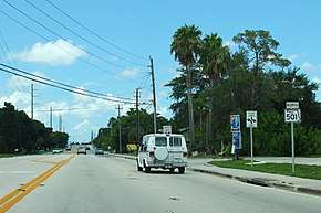
Northbound on Florida State Road 501 in Cocoa, Florida.
The entire route is in Brevard County.
| Location | mi[1] | km | Destinations | Notes | |
|---|---|---|---|---|---|
| | 0.000 | 0.000 | |||
| Cocoa | 1.193 | 1.920 | Dixon Boulevard (CR 503 east) | ||
| 3.358 | 5.404 | ||||
| 1.000 mi = 1.609 km; 1.000 km = 0.621 mi | |||||
References
- 1 2 FDOT Straight Line Diagram of Road Inventory for State Road 501 (PDF File), accessed 30 November 2017
| Wikimedia Commons has media related to Florida State Road 501. |
This article is issued from
Wikipedia.
The text is licensed under Creative Commons - Attribution - Sharealike.
Additional terms may apply for the media files.