California State Route 32
| ||||
|---|---|---|---|---|
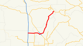 SR 32 highlighted in red | ||||
| Route information | ||||
| Defined by Streets and Highways Code § 332 | ||||
| Maintained by Caltrans | ||||
| Length | 74.387 mi[1] (119.714 km) | |||
| Existed | 1934 – present | |||
| Major junctions | ||||
| West end |
| |||
| ||||
| East end |
| |||
| Location | ||||
| Counties | Glenn, Butte, Tehama | |||
| Highway system | ||||
| ||||

State Route 32 (SR 32) is an east–west state highway in the U.S. State of California which is routed from Interstate 5 in Orland, through Chico, through the northern Sierra Nevada, ending at SR 36 and SR 89 in eastern Tehama County.
Route description
SR 32 begins in Orland at a junction with I-5 as Newville Road. The highway continues east out of Orland for several miles before entering Hamilton City and intersecting SR 45. SR 32 then crosses the Sacramento River into Butte County. East of here, SR 32 enters the city of Chico, becoming Walnut Street before it becomes a one-way couplet as 8th and 9th Streets through downtown Chico. Shortly after the diamond interchange with the SR 99 freeway, 8th and 9th Streets merge into one road and SR 32 continues east out of the Chico city limits. [2]
Following this, SR 32 turns to the northeast, passing through the communities of Forest Ranch and West Branch before crossing into Tehama County and eventually Lassen National Forest. SR 32 terminates at an intersection with SR 89 and SR 36.[2]
Different road names include Nord Avenue (Chico), Walnut Street (Chico), West Eighth and Ninth Streets (Chico), East Eighth and Ninth Streets (Chico), Deer Creek Highway (Chico), East and West Sixth Street (Hamilton City), Walker Street (Orland), Newville Road (Orland) and County Road 200.
SR 32 is part of the California Freeway and Expressway System,[3] and between I-5 and SR 99 is part of the National Highway System,[4] a network of highways that are considered essential to the country's economy, defense, and mobility by the Federal Highway Administration.[5]
Major intersections
Except where prefixed with a letter, postmiles were measured on the road as it was in 1964, based on the alignment that existed at the time, and do not necessarily reflect current mileage. R reflects a realignment in the route since then, M indicates a second realignment, L refers an overlap due to a correction or change, and T indicates postmiles classified as temporary (for a full list of prefixes, see the list of postmile definitions).[1] Segments that remain unconstructed or have been relinquished to local control may be omitted. The numbers reset at county lines; the start and end postmiles in each county are given in the county column.
| County | Location | Postmile [1][6][7] | Destinations | Notes | ||||
|---|---|---|---|---|---|---|---|---|
| Glenn GLE L0.00-10.91 | Orland | L0.00 | Road 200 – Newville | Continuation beyond I-5 | ||||
| L0.00 | Interchange; west end of SR 32 | |||||||
| 0.00 | Former US 99W | |||||||
| Hamilton City | 9.63 | |||||||
| Butte BUT 0.00-37.75 | | 6.24 | ||||||
| Chico | 9.08 | Serves California State University Chico | ||||||
| 10.19 | Interchange | |||||||
| Tehama TEH 0.00-2.71 |
No major junctions | |||||||
| Butte BUT 2.71-4.70 |
No major junctions | |||||||
| Tehama TEH 4.70-R24.88 | | R24.88 | East end of SR 32 | |||||
| 1.000 mi = 1.609 km; 1.000 km = 0.621 mi | ||||||||
See also

References
- 1 2 3 California Department of Transportation. "State Truck Route List". Sacramento: California Department of Transportation. Archived from the original (XLS file) on June 30, 2015. Retrieved June 30, 2015.
- 1 2 California Road Atlas (Map). Thomas Brothers. 2008.
- ↑ California State Legislature. "Section 250–257". Streets and Highways Code. Sacramento: California State Legislature. Retrieved June 9, 2017.
- ↑ Federal Highway Administration (March 25, 2015). National Highway System: California (North) (PDF) (Map). Scale not given. Washington, DC: Federal Highway Administration. Retrieved October 18, 2017.
- ↑ Natzke, Stefan; Neathery, Mike & Adderly, Kevin (June 20, 2012). "What is the National Highway System?". National Highway System. Washington, DC: Federal Highway Administration. Retrieved July 1, 2012.
- ↑ California Department of Transportation (July 2007). "Log of Bridges on State Highways". Sacramento: California Department of Transportation.
- ↑ California Department of Transportation, All Traffic Volumes on CSHS, 2005 and 2006
External links
Route map:
| Wikimedia Commons has media related to California State Route 32. |