Söğüt
| Söğüt | |
|---|---|
| Town | |
 Söğüt | |
| Coordinates: 40°1′7″N 30°10′53″E / 40.01861°N 30.18139°ECoordinates: 40°1′7″N 30°10′53″E / 40.01861°N 30.18139°E | |
| Country |
|
| Region | Marmara |
| Province | Bilecik |
| Government | |
| • Mayor | Osman Güneş (AKP) |
| • Governor | Berkan Sönmezay |
| Area[1] | |
| • District | 530.21 km2 (204.72 sq mi) |
| Population (2012)[2] | |
| • Urban | 13,891 |
| • District | 19,842 |
| • District density | 37/km2 (97/sq mi) |
| Time zone | UTC+3 (FET) |
| Postal code | 11600 |
| Area code(s) | (+90) 0228 |
| Licence plate | 11 |
| Website | www.sogut.bel.tr |
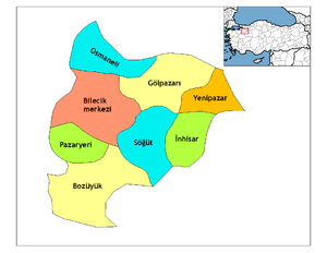
Söğüt ([søʲyt]) is a town and district in Bilecik Province, Turkey. It is located in the Marmara region in the north-west of the country, with an area of 599 km2 (231 sq mi), bordering Bilecik to the west, Gölpazarı to the north, İnhisar to the north-east, Tepebaşı (Eskişehir) to the south-east, and Bozüyük to the south-west. Söğüt district has 5 boroughs and 23 villages, with the population last recorded as 21,012 citizens (2000), but according to a 2010 estimate the population was 19,425.
Söğüt is notable as the founding location and first capital of the Ottoman Empire from 1299 to 1335.
History
Söğüt was a Seljuk Turkish tribe in western Anatolia that later gave birth to the Ottoman Empire. It was a small but sophisticated tribe that extended from the Kayi branch of the Seljuk Turks that in the 12th and 13th centuries invaded Anatolia. The village of Söğüt was surrounded by three greater Turkish tribes; Eskenderum in the north, Eskişehir in the east, Konyali in the south; and with the Byzantine Empire in the west. Legend has it that the bey (chief) of the tribe in the late 13th century, Ertuğrul, bravely kept the enemies at bay so that his son, Osman, could conquer them all during his reign, 1299 to 1326. When Osman's son, Orhan, came to power after his father's death he renamed the tribe Osmanli in honour of his father. The village of Söğüt (formerly Thebasion until 1231) later grew into a town that served the Osmanli tribe as capital until the capture of the Byzantine city of Bursa in 1326 when the capital was moved to the far more luxurious palaces of the Byzantines.
Söğüt was the birthplace of Sultan Osman I. It was conquered by Ertuğrul for the Anatolian Seljuks from the Nicean Empire in 1231. It was called Thebasion before the Turkish conquest. It had a kaza centre in Ertuğrul Sanjak (Its centre was Bilecik) of Hüdavendigâr Vilayet and also included present districts of İnhisar, İnönü, Mihalgazi, Sarıcakaya and Yenipazar, central and eastern parts of Bozüyük one and some villages of Nallıhan and Tepebaşı ones before World War I. It was occupied three times by Greek troops (8-11 January 1921, 24 March-21 April 1921 and 12 July 1921-6 September 1922) during Turkish War of Independence.
Today
Today Söğüt is a small town in the humid river valley of Bilecik Province in Turkey. Turkish history and life-size statues of the Ottoman sultans are exhibited in the Söğüt Ethnographical Museum. It is also the 3rd biggest district center in its province after Bozüyük and Bilecik. Its market is open every Thursday and some people visit the city from the districts of İnhisar and Yenipazar for shopping.
References
- ↑ "Area of regions (including lakes), km²". Regional Statistics Database. Turkish Statistical Institute. 2002. Retrieved 2013-03-05.
- ↑ "Population of province/district centers and towns/villages by districts - 2012". Address Based Population Registration System (ABPRS) Database. Turkish Statistical Institute. Retrieved 2013-02-27.
External links
| Wikimedia Commons has media related to Söğüt. |