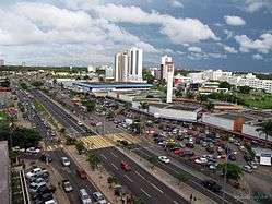
São Luís, Maranhão
| São Luís | |||
|---|---|---|---|
| Municipality | |||
|
The Municipality of São Luís do Maranhão | |||
 | |||
| |||
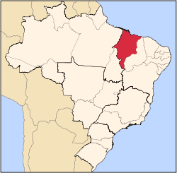
 Location of São Luís | |||
 São Luís Location in Brazil | |||
| Coordinates: 2°31′42″S 44°18′16″W / 2.52833°S 44.30444°W | |||
| Country |
| ||
| Region | Northeast | ||
| State |
| ||
| Founded | September 8, 1612 | ||
| Government | |||
| • Mayor | Edivaldo Holanda Júnior (PDT) | ||
| Area | |||
| • Municipality | 827.141 km2 (319.360 sq mi) | ||
| Elevation | 4 m (12 ft) | ||
| Population (2010 IBGE) | |||
| • Municipality | 1,011,943 | ||
| • Density | 1,183.4/km2 (3,064.9/sq mi) | ||
| • Metro | 1,227,659 | ||
| Time zone | UTC-3 (UTC-3) | ||
| Postal Code | 65000-000 | ||
| Area code(s) | +55 98 | ||
| Website | São Luís, Maranhão | ||


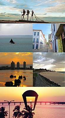
São Luís (Brazilian Portuguese: [sɐ̃w luˈis],[1] Saint Louis) is the capital and largest city of the Brazilian state of Maranhão. The city is located on Upaon-açu Island (Big Island, in Tupi Language) or Ilha de São Luís (Saint Louis' Island), in the Baía de São Marcos (Saint Mark's Bay), an extension of the Atlantic Ocean which forms the estuary of Pindaré, Mearim, Itapecuru and other rivers. Its coordinates are 2.53° south, 44.30° west. São Luís has the second largest maritime extension within Brazilian states. Its maritime extension is 640 km (397 miles). The city proper has a population of some 1,082,935 people (2016 IBGE estimate). The metropolitan area totals 1,605,305, ranked as the 15th largest in Brazil.
São Luís, created originally as Saint-Louis-de-Maragnan, is the only Brazilian state capital founded by France (see France Équinoxiale) and it is one of the three Brazilian state capitals located on islands (the others are Vitória and Florianópolis).
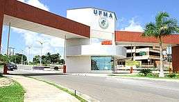
The city has two major sea ports: Madeira Port and Itaqui Port, through which a substantial part of Brazil's iron ore, originating from the (pre)-Amazon region, is exported. The city's main industries are metallurgical with Alumar, and VALE. São Luís is home of the Federal University of Maranhão.
São Luís was the home town of famous Brazilian samba singer Alcione, Brazilian writers Aluísio Azevedo, Ferreira Gullar and Josué Montello, Belgian-naturalised soccer player Luís Oliveira, and the musician João do Vale and Zeca Baleiro, a Música popular brasileira (MPB) singer.
History
Originally the town was a large village of the Tupinambá tribe. The first Europeans to settle it were the French, in 1612, who intended to make it the center of a colony named Equinoctial France, under the command of Daniel de la Touche, Seigneur de la Ravardière, and Admiral François de Razilly. They built a fort named Saint-Louis de Maragnan after King Louis XIII and his Saintly ancestor Louis IX. The settlement was conquered for Portugal by Jerônimo de Albuquerque in 1615, when it was renamed São Luís. There had been little time for the French to build a city, a fact which has led to some controversy as to the actual date of the founding of the city, whether by the French or the Portuguese. In 1641, the city was invaded by the Dutch, who left in 1645. In 1677, the city was made the seat of the new Roman Catholic Diocese of São Luís do Maranhão.

Only when those invasions ceased permanently did the colonial government decide to create the state of Grão-Pará e Maranhão, independent from the rest of the country. By that time, the economy was based on agriculture, particularly the exportation of sugar cane, cacao and tobacco. Conflicts amongst the local elites would lead to the Beckman's Revolt. This started due the struggle between Jesuits and landowners, the first against the Indian slavery and the others against the unfair treatment given by the Portuguese authorities; the situation lead to an uprising against the Portuguese, led by the brothers Manuel and Tomás Beckman and lasted till the intervention of Portuguese troops under the command of the general Gomes Freire de Andrade. After few skirmishes, the rebels were defeated and the Beckman brothers arrested and, after a brief trial, were hanged, drawn and quartered. The last words of Manuel Beckman at the gallows were "Pelo Povo do Maranhão morro contente" ("By the Maranhão people I die happy"). The phrase decorates the main hall of State Council Building.
Soon after the outbreak of the American Civil War, the region started to provide cotton to Great Britain. The wealth generated by this activity was used to modernize the city; to bring religious men to come and teach in its schools; and supplement the water supply. The city came to be the third most populous city in the country. By the end of the 19th century, agriculture was in decay and since then the city's population has been searching for other ways to make a living.
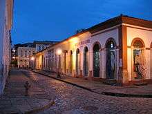
Nowadays, São Luís has the largest and best preserved heritage of colonial Portuguese architecture of all Latin America. The island is known as the "Island of Love" and as "the Brazilian Athens", due to its many poets and writers, such as Sotero dos Reis, Aluísio Azevedo, Graça Aranha, Gonçalves Dias (the most famous), Josué Montello, Ferreira Gullar, among others. The city is also known as "the Brazilian Jamaica" because of the popularity of Reggae Music.
The ancestral composition of São Luís, according to an autosomal DNA study, is 42% European, 39% Native American and 19% African.[2]
Economy
Until the mid-nineteenth century, Maranhão's economy was one of the most prosperous in the country. However, after the Civil War in the United States of America, when it lost space in the export of cotton and the state went into decline. Only after the end of the 1960s did the state begin to receive incentives and emerge from seclusion, by way of road and rail connections with other regions.
In the late eighteenth century, increased international demand for cotton to meet the English textile industry coupled with reduced production because of the North American War of Independence in the United States provided the perfect setting to stimulate cotton production in Maranhão. Shipping companies and Southampton & Company Maranha Maranha Shipping Company, shipping steam, which performed the transportation of cotton from the states of Georgia and Alabama, began operating in St. Louis shaft - London, leading to production of Caxias and Baixada Maranhão. By the early twentieth century, St. Louis still exporting cotton to England by sea, through the lines and Booth Red Cross Line Line (the extended route to Iquitos) and company-Maranha Liverpool Shipping Company.
During this golden period of the Maranhão economy, São Luís was a living cultural effervescence. The city had more in common with the European capitals than the other Brazilian cities. It was the first to receive an Italian opera and received the latest news about French literature every week. The rich cotton producers and local businessmen sent their children to study in Recife, Salvador, Rio de Janeiro as far as Europe.
The opening of the Port of Alumar, Port of Itaqui and Port of Ponta da Madeira, currently the second deepest in the world, second only to the Rotterdam, is one of the busiest in the country. It serves as a gateway for industrial production and iron ore arriving from the Carajás Railway, operated by Companhia Vale do Rio Doce and also exports soybeans grown in southern Maranhão and central Brazil, transported by the Carajás Railway and North-South Railway. The port's proximity to strategic markets in Europe and North America has led it to become an attractive option for exporting goods, but suffers from increased coastal shipping.
The São Luís economy is based on aluminum processing, food production and tourism. São Luís has the largest GDP in the state, hosting two public universities (and UFMA UEMA) and various educational institutions and private colleges. According to the latest data from the IBGE survey, São Luís has a GDP of R$9,340,944,000.00, occupying14th position amongst state capitals.
Geography
The island of Upaon-Açu is located between two large estuarine systems that are the bays of São Marcos on the right side and São José on the left side in the central region of Golfão Maranhense. The two bays are interconnected in the southwest by the channels of the Strait of Mosquitoes and Strait of Coqueiros (separating the island of Upaon-Açu from the island of Tauá-Mirim). [3]
In the São Marcos bay, the watershed of the Mearim river and its tributaries flows, while in the São José/Arraial bay the watersheds of the Itapecuru and Munim rivers break. In this region, the amplitude of the tides can exceed seven meters. The region presents numerous streams and tidal channels. Several agents have modeled relief such as those of climatic, hydrological and oceanographic origin, as well as intense wind, marine and fluvial activity, with vegetation characterized by remnants of the Amazonian Forest, Mangroves and Campo de Perizes, an extensive fluvial plain with predominantly herbaceous, located on the mainland.[3]
The climate is characterized as hot, semi-humid, tropical of equatorial zone, with two distinct seasons that go from damp (January to June) the drought (July to December), with average rainfall of 2,200 mm per year. Some of the conservation units of the island are: APA das Reentrancias Maranhenses; APA of Upaon-Açu-Miritiba-Alto Preguiças, APA of Itapiracó; APA of the Maracanã Region; and the Bacanga State Parks, the Jansen Lagoon and the Rangedor. [3]
On the Strait of Mosquitoes, there are road and railroad bridges linking the mainland to Upaon-Açu Island: the Marcelino Machado bridge, BR-135, composed of two parallel inlet and outlet bridges (456 and 454 meters in length); the metal bridge Benedito Leite, belonging to the São Luís-Teresina Railway; the duplicate bridge belonging to the Carajás Railroad; the metal bridge that supports the Italuís waterway, which carries water from the river Itapecuru to the city of São Luís. [3]
There is also a ferry service, between São Luís and Alcântara; and São Luís International Airport.[3]
Climate
The city of São Luís experiences a borderline between tropical savanna climate and tropical monsoon climate, (Aw and Am) with a short dry season from August to November. During this period when the equatorial rainband associated with the highly seasonalized positioning of the Intertropical Convergence Zone is not over the city, warm to hot temperatures and abundant equatorial sunshine prevail. Conversely, the humid, rainy wet season dominates the remaining majority of the year, with abundant cloud cover prevalent and heavy rains falling from December to July, with the heaviest rainfall and highest cloud cover from January to May. The cloudiest month of the year is March with a monthly average of 107.2 hours of bright sunshine throughout the month, while the sunniest month of the year is August with a monthly average of 260.3 hours of sunshine throughout the month. The wettest month is April with an average monthly total of 476 mm (18.74 in) of precipitation, while the driest month is October with an average total of average precipitation total of 8 mm (0.31 in). Nearly 70 per cent of average annual precipitation is recorded on average from February to May.
The municipality contains part of the 1,535,310 hectares (3,793,800 acres) Upaon-Açu/Miritiba/Alto Preguiças Environmental Protection Area, created in 1992.[4] The city is home to the Sítio Rangedor State Park, formerly the fully protected Sítio Rangedor Ecological Station.[5] The municipality also contains a small part of the Baixada Maranhense Environmental Protection Area, a 1,775,035.6 hectares (4,386,208 acres) sustainable use conservation unit created in 1991 that has been a Ramsar Site since 2000.[6] The 2,634 hectares (6,510 acres) Bacanga State Park is just south of the city.[7]
| Climate data for São Luís (1961–1990) | |||||||||||||
|---|---|---|---|---|---|---|---|---|---|---|---|---|---|
| Month | Jan | Feb | Mar | Apr | May | Jun | Jul | Aug | Sep | Oct | Nov | Dec | Year |
| Record high °C (°F) | 33.6 (92.5) |
36.0 (96.8) |
32.8 (91) |
33.0 (91.4) |
33.2 (91.8) |
33.1 (91.6) |
32.7 (90.9) |
34.4 (93.9) |
34.0 (93.2) |
33.2 (91.8) |
34.4 (93.9) |
33.8 (92.8) |
36.0 (96.8) |
| Average high °C (°F) | 30.0 (86) |
29.4 (84.9) |
29.4 (84.9) |
29.6 (85.3) |
30.1 (86.2) |
30.4 (86.7) |
30.2 (86.4) |
30.7 (87.3) |
31.0 (87.8) |
31.2 (88.2) |
31.4 (88.5) |
31.1 (88) |
30.4 (86.7) |
| Daily mean °C (°F) | 26.1 (79) |
25.7 (78.3) |
25.6 (78.1) |
25.8 (78.4) |
25.9 (78.6) |
25.9 (78.6) |
25.6 (78.1) |
25.9 (78.6) |
26.3 (79.3) |
26.6 (79.9) |
26.9 (80.4) |
26.7 (80.1) |
26.1 (79) |
| Average low °C (°F) | 23.5 (74.3) |
23.1 (73.6) |
23.0 (73.4) |
23.1 (73.6) |
23.1 (73.6) |
22.9 (73.2) |
22.6 (72.7) |
23.0 (73.4) |
23.5 (74.3) |
23.7 (74.7) |
24.0 (75.2) |
24.0 (75.2) |
23.3 (73.9) |
| Record low °C (°F) | 20.0 (68) |
20.1 (68.2) |
17.9 (64.2) |
13.1 (55.6) |
20.2 (68.4) |
20.6 (69.1) |
18.1 (64.6) |
20.3 (68.5) |
20.9 (69.6) |
21.2 (70.2) |
21.6 (70.9) |
20.0 (68) |
13.1 (55.6) |
| Average rainfall mm (inches) | 244.2 (9.614) |
373.0 (14.685) |
428.0 (16.85) |
475.9 (18.736) |
316.5 (12.461) |
173.3 (6.823) |
131.1 (5.161) |
29.4 (1.157) |
23.3 (0.917) |
7.6 (0.299) |
10.5 (0.413) |
77.4 (3.047) |
2,290 (90.16) |
| Average rainy days (≥ 1 mm) | 13 | 17 | 23 | 22 | 20 | 13 | 10 | 4 | 2 | 1 | 1 | 4 | 130 |
| Average relative humidity (%) | 85 | 88 | 89 | 90 | 89 | 86 | 86 | 84 | 81 | 81 | 79 | 71 | 84.9 |
| Mean monthly sunshine hours | 152.6 | 113.7 | 107.2 | 113.7 | 162.6 | 213.1 | 237.6 | 260.3 | 249.9 | 251.8 | 244.1 | 206.3 | 2,312.9 |
| Source: Brazilian National Institute of Meteorology (INMET).[8][9][10][11][12][13][14][15][16] | |||||||||||||
Education
Portuguese is the official national language, and thus the primary language taught in schools. But English and Spanish are part of the official high school curriculum.
Educational institutions include:
- Universidade Federal do Maranhão (UFMA)
- Universidade Estadual do Maranhão (UEMA)
- Faculdade Santa Terezinha (CEST)
- Centro de Ensino Universitário do Maranhão (UNICEUMA)
- Instituto Federal de Educação, Ciência e Tecnologia do Maranhão (IFMA)
- Faculdade São Luís
- Unidade de Ensino Superior Dom Bosco (UNDB)
- Faculdade Atenas Maranhense (FAMA)
- Faculdade do Maranhão (FACAM)
- Faculdade Pitágoras
Culture
| UNESCO World Heritage site | |
|---|---|
 | |
| Criteria | Cultural: iii, iv, v |
| Reference | 821 |
| Inscription | 1997 (21st Session) |
| Area | 66.65 ha |
São Luís is known for its tiles which most buildings in the historical centre are covered in. Because of it the city is also known as "The Tiles City" and "Brazilian Athens".
It also has some cultural peculiarities namely:
Tambor de Crioula
Afro-Brazilian dance in which gaily clad women court a bateria of tambors (a row of drums). Whirling and gyrating in time to the music they negotiate for prime position in the centre of the bateria.
Tambor de Mina
Not to be confused with the above, this is the local variant of the Afro-Brazilian religion Candomblé.
Bumba Meu Boi

The Bumba Meu Boi is a popular farce which takes its form as a grand musical pantomime. Practice is a public affair and begins directly after Easter reaching its climax in June when literally hundreds of groups perform on a nightly basis for popular acclaim. Set personalities and characters play out a comedic tragedy with a metaphor for social harmony at its heart. Settlers, the infamous "Coroneis", Indians, spirit workers, African slaves and forest spirits are enacted though costumes, choreography and music - all performed amongst the all-night revelry. The crowd joins in with singing, dancing and dependent on the groups sotaque (or style) the playing of matracas (two wooden blocks, held in each hand and struck together repeatedly). Like the festival of Sao João and its requisite Forró dance in the North-Eastern states further south Bumba Meu Boi is a harvest festival but with the bull as its centre-piece.
Capoeira
The São Luís form of capoeira is said to be akin to the kind of capoeira now recognized as 'traditional bahian capoeira' that predated the Bahian Angola/regional polemic which split the capoeira world in the 1950s.
Historical center
In 1997 the city's historical center was made a UNESCO World Heritage Site. Starting in 1989 there has been an extensive program to restore and renovate the colonial era buildings of the city's historical center.
Reggae
São Luís is known as the Brazilian capital of reggae, a very popular rhythm in the city. In 2018, the Reggae Museum of Maranhão was founded, the first museum dedicated to reggae outside of Jamaica and the second in the world.
Transportation

The city is served by the Marechal Cunha Machado International Airport.
There are 184 bus lines operating in the metropolitan area, served by a fleet of more than 3,000 buses. More than 500,000 people use the bus system every day. The metropolitan area has a network of alternative transportation that works with drivers who usually have their own coach and organize themselves into cooperatives to enable them to provide the public transport service duly legalized in the department of city traffic.
The city has also an efficient radio system with more than 2000 taxi cabs accredited.
Sao Luis is home to a port that receives boats that carry passengers across to the city of Alcantara, which is located in the metropolitan area. It also has another port that receives ferries carrying people and cars that are destined for cities in the region of the state known as the low lands.
Being an island, the city has only one output ground, the bridge of the Estreito dos Mosquitos, which links the island of Sao Luis by road BR-135.

Telecommunications
Local area phone code (named DDD in Brazil) to call São Luis city is 98 (DDD98).[17]
Sports
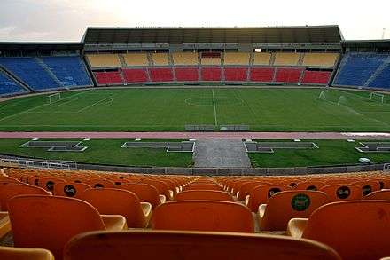
Soccer is the most popular sport in São Luís, though its clubs aren't much well known in the rest of Brazil. The professional clubs in São Luís are: Sampaio Corrêa who currently play in Brazil's second division, Moto Club who play in the fourth division and Maranhão Atlético Clube who take part in the regional Campeonato Maranhense.
Notable residents
- Maria Firmina dos Reis (1825–1917), abolitionist and author.
- Dan Kearns (born 1956), Canadian football player.
- Steve Kearns (born 1956), Canadian football player.
- Aluísio de Azevedo (1857-1913), Brazilian writer and diplomat.
- Artur Azevedo (1855-1908), Brazilian writer and poet.
- Alcione Nazareth (born 1947), Brazilian singer.
References
- ↑ The European Portuguese pronunciation is [sɐ̃w luˈiʃ].
- ↑
- 1 2 3 4 5 www.neopixdesign.com.br, Neopix Design ©. "Trabalhos técnicos do XXII SBRH - PARAMETROS FISICO-QUÍMICOS E NUTRIENTES INORGÂNICOS DISSOLVIDOS NO RIO PERIZES/BAIA DE SÃO JOSÉ DE RIBAMAR, ILHA DE SÃO LUIS - MA". evolvedoc.com.br. Retrieved 2018-06-27.
- ↑ APA Upaon-Açu/Miritiba/Alto Preguiças (in Portuguese), ISA: Instituto Socioambiental, retrieved 2017-02-09
- ↑ Aurina Carneiro (11 May 2016), Plenário aprova projeto que altera Estação Ecológica do Sítio do Rangedor (in Portuguese), Agência Assembleia, retrieved 2016-05-17
- ↑ APA Baixada Maranhense (in Portuguese), ISA: Instituto Socioambiental, retrieved 2016-06-13
- ↑ PES do Bacanga (in Portuguese), ISA: Instituto Socioambiental, retrieved 2016-08-03
- ↑ "Temperatura Média Compensada (°C)" (in Portuguese). Brazilian National Institute of Meteorology. 1961–1990. Archived from the original on May 5, 2014. Retrieved September 8, 2014.
- ↑ "Temperatura Máxima (°C)" (in Portuguese). Brazilian National Institute of Meteorology. 1961–1990. Archived from the original on May 5, 2014. Retrieved September 8, 2014.
- ↑ "Temperatura Mínima (°C)" (in Portuguese). Brazilian National Institute of Meteorology. 1961–1990. Archived from the original on May 5, 2014. Retrieved September 8, 2014.
- ↑ "Precipitação Acumulada Mensal e Anual (mm)" (in Portuguese). Brazilian National Institute of Meteorology. 1961–1990. Archived from the original on May 5, 2014. Retrieved September 8, 2014.
- ↑ "Número de Dias com Precipitação Maior ou Igual a 1 mm (dias)". Brazilian National Institute of Meteorology. Archived from the original on May 5, 2014. Retrieved September 8, 2014.
- ↑ "Insolação Total (horas)". Brazilian National Institute of Meteorology. Archived from the original on May 5, 2014. Retrieved September 8, 2014.
- ↑ "Umidade Relativa do Ar Média Compensada (%)". Brazilian National Institute of Meteorology. Archived from the original on May 5, 2014. Retrieved September 8, 2014.
- ↑ "Temperatura Máxima Absoluta (ºC)". Brazilian National Institute of Meteorology (Inmet). Retrieved September 8, 2014.
- ↑ "Temperatura Mínima Absoluta (ºC)". Brazilian National Institute of Meteorology (Inmet). Retrieved September 8, 2014.
- ↑ "São Luis do Maranhao, DDD98 area phone code". Retrieved December 12, 2012.
External links
Coordinates: 2°31′42″S 44°18′16″W / 2.5283°S 44.3044°W
World Heritage Sites in Brazil | ||
|---|---|---|
| North Region |  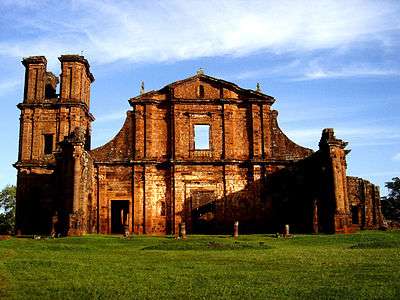 | |
| Northeast Region |
| |
| Central-West Region |
| |
| Southeast Region |
| |
| South Region |
| |