Hinderwell
| Hinderwell | |
|---|---|
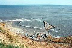 Derelict harbour at Port Mulgrave, near Hinderwell, North Yorkshire | |
 Hinderwell Hinderwell shown within North Yorkshire | |
| Population | 1,875 (2011 census)[1] |
| OS grid reference | NZ792167 |
| Civil parish |
|
| District | |
| Shire county | |
| Region | |
| Country | England |
| Sovereign state | United Kingdom |
| Post town | SALTBURN-BY-THE-SEA |
| Postcode district | TS13 |
| Police | North Yorkshire |
| Fire | North Yorkshire |
| Ambulance | Yorkshire |
| EU Parliament | Yorkshire and the Humber |
| UK Parliament | |
Hinderwell is a village and civil parish in the Scarborough district of North Yorkshire, England which lies within the North York Moors National Park.
Hinderwell lies about a mile from the coast on the A174 road between the towns of Loftus and Whitby. It may also be visited by the Cleveland Way National Trail. Until 1958 the area was served by Staithes and Hinderwell railway stations.
The civil parish of Hinderwell encompasses:
- the village of Staithes
- the hamlet of Port Mulgrave grid reference NZ794174
- the National Trust land called Rosedale Cliffs NZ798174
- the hamlet of Runswick Bay NZ806161, a popular beach resort with a lifeboat service operated independently since 1982.[2]
- the hamlet of Dalehouse NZ777180
According to the 2011 UK census, Hinderwell parish had a population of 1,875,[1] a decrease on the 2001 UK census figure of 2,103.[3]
References
- 1 2 UK Census (2011). "Local Area Report – Hinderwell Parish (1170217346)". Nomis. Office for National Statistics. Retrieved 4 March 2018.
- ↑ "Runswick Bay Rescue Service". Retrieved 12 August 2017.
- ↑ "2001 Census: Key Statistics: Parish Headcounts: Area: Hinderwell CP (Parish)". Neighbourhood Statistics. Office for National Statistics. Retrieved 7 July 2008.
External links
![]()
- Village website
- The ancient parish of Hinderwell: historical and genealogical information at GENUKI.
- Supplementary GENUKI page
This article is issued from
Wikipedia.
The text is licensed under Creative Commons - Attribution - Sharealike.
Additional terms may apply for the media files.