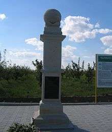
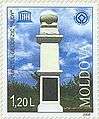
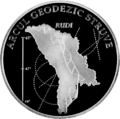
Rudi Geodetic Point
| Punctul Geodezic Rudi | |
 | |
| Coordinates | 48°19′08″N 27°52′36″E / 48.31889°N 27.87667°ECoordinates: 48°19′08″N 27°52′36″E / 48.31889°N 27.87667°E |
|---|---|
| Type | Obelisk |
| Opening date | June 17, 2006 |
| Dedicated to | Struve Geodetic Arc |
The Rudi Geodetic Point (Romanian: Punctul Geodezic Rudi) is a point of the Struve Geodetic Arc in Rudi, Moldova. There is also an obelisk.
Overview
Rudi Geodetic Point was set up in 1847 and is a World Heritage Site (2005). The obelisk was opened on June 17, 2006.
Gallery
External links
| Wikimedia Commons has media related to Rudi Geodetic Point. |
This article is issued from
Wikipedia.
The text is licensed under Creative Commons - Attribution - Sharealike.
Additional terms may apply for the media files.