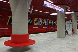
Rondo Daszyńskiego metro station
Rondo Daszyńskiego | |||||||||||
|---|---|---|---|---|---|---|---|---|---|---|---|
 | |||||||||||
| Coordinates | 52°13′48.5″N 20°59′00″E / 52.230139°N 20.98333°ECoordinates: 52°13′48.5″N 20°59′00″E / 52.230139°N 20.98333°E | ||||||||||
| Owned by | ZTM Warszawa | ||||||||||
| Platforms | 1 island platform | ||||||||||
| Tracks | 2 | ||||||||||
| Connections |
| ||||||||||
| Construction | |||||||||||
| Platform levels | 1 | ||||||||||
| Other information | |||||||||||
| Station code | C-9 | ||||||||||
| Fare zone | 1 | ||||||||||
| History | |||||||||||
| Opened | 8 March 2015 | ||||||||||
| Services | |||||||||||
| |||||||||||
Rondo Daszyńskiego is the first station of the central part of Line M2 of the Warsaw Metro.
The station fully opened for passenger use on 8 March 2015.[1]
The station is located just west of Rondo Daszyńskiego (Daszyński Roundabout), named in honor of Ignacy Daszyński.
Construction of the station was made difficult by adverse hydrological conditions.[2]
References
- ↑
- ↑ Koda, E.; E. Wiencław (2006). "Prognoza wpływu odwodnienia w rejonie projektowanego wykopu stacji II lini metra w Warszawie". Zeszyty Naukowe Politechniki Białostockiej. University of Białystok. 28 (2): 151–162.
External links
- Detailed map of Line M2 from official Warsaw Metro site
- Detailed plan of Rondo Daszyńskiego station from official Warsaw Metro site
![]()
(north to south) | ||
|---|---|---|
(west to east) | ||
This article is issued from
Wikipedia.
The text is licensed under Creative Commons - Attribution - Sharealike.
Additional terms may apply for the media files.