Rofla Gorge
| Rofla Gorge | |
|---|---|
| Romansh: Puntcrap, German: Roflaschlucht | |
 Rofla Gorge footpath | |
 | |
| Floor elevation | approx. 1,144 metres (3,800 ft) |
| Length | 2 kilometres (1.2 mi) |
| Width | 0.5 to 0.012 kilometres (0.3107 to 0.0075 mi) |
| Geography | |
| Location | The Grisons |
| Coordinates | 46°20′N 9°15′E / 46.34°N 9.25°ECoordinates: 46°20′N 9°15′E / 46.34°N 9.25°E |
| Traversed by | San Bernandino route |
| Rivers | Rein Posteriur |
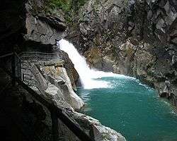
The Rofla Gorge (Romansh: Puntcrap, German: Roflaschlucht) is an ancient and narrow section of the river Hinterrhein/Rein Posteriur between Sufers and Andeer in the canton of Graubünden. This narrow gorge was another obstacle on the approach to the two mountain passes Splügen Pass und San Bernardino Pass in addition to the Viamala gorge.
Modern era
Nowadays the mountains can be crossed on the A13 motorway, opened in 1967, which passes through the San Bernardino Tunnel and is therefore open all year round (whereas both passes were closed in winter). The older, main road passes the hotel at the entrance of the gorge, from where there is a footpath to and under the waterfall. The path was built from 1907 to 1914 by the family who owned the hotel.
See also
External links
| Wikimedia Commons has media related to [[commons:Category:Rofflaschlucht|]]. |
This article is issued from
Wikipedia.
The text is licensed under Creative Commons - Attribution - Sharealike.
Additional terms may apply for the media files.