Riyadh Air Base
| Riyadh Air Base | |||||||||||||||
|---|---|---|---|---|---|---|---|---|---|---|---|---|---|---|---|
| Summary | |||||||||||||||
| Airport type | Military | ||||||||||||||
| Owner | Armed Forces of Saudi Arabia | ||||||||||||||
| Operator | Royal Saudi Air Force | ||||||||||||||
| Location | Riyadh, Saudi Arabia | ||||||||||||||
| Elevation AMSL | 635 m / 2,083 ft | ||||||||||||||
| Coordinates | 24°42′35″N 46°43′31″E / 24.70972°N 46.72528°ECoordinates: 24°42′35″N 46°43′31″E / 24.70972°N 46.72528°E | ||||||||||||||
| Runways | |||||||||||||||
| |||||||||||||||
Riyadh Air Base (ICAO: OERY, Arabic: قاعدة الرياض الجوية) formerly Riyadh International Airport until 1982 is an airport in Riyadh, Saudi Arabia.
History
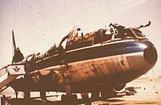
The aftermath of the Fire that destroyed Saudia 163.
Originally used for commercial flights by Saudi Arabia Airlines, the airport witnessed the destruction of Saudia Flight 163 on the night of August 19 1980. The Lockheed L-1011-200 was attempting to return when it burst into flames on the tarmac.
In 1982, King Khalid International Airport was opened which lead to this airport becoming a Military base for the Royal Saudi Air Force.
Current Status
K. Faisal Academy is on the air base and uses Pilatus PC-9's for pilot training. OERY has two crossing runways. 19-01 is the alpha and 15-30 is the bravo. It is home to the Civil Defense fleet as well.
References
External links
- Airport information for OERY at World Aero Data. Data current as of October 2006.
This article is issued from
Wikipedia.
The text is licensed under Creative Commons - Attribution - Sharealike.
Additional terms may apply for the media files.