Lydney Canal
| Lydney Canal | |||||||||||||||||||||||||||||||||||||||||||||||||||||||||||||||
|---|---|---|---|---|---|---|---|---|---|---|---|---|---|---|---|---|---|---|---|---|---|---|---|---|---|---|---|---|---|---|---|---|---|---|---|---|---|---|---|---|---|---|---|---|---|---|---|---|---|---|---|---|---|---|---|---|---|---|---|---|---|---|---|
| |||||||||||||||||||||||||||||||||||||||||||||||||||||||||||||||


This one-mile canal in Gloucestershire runs inland from the River Severn to Lydney. It was opened in 1813 to trans-ship iron and coal from the Forest of Dean. It was once connected by a horse drawn tramroad to Pidcock's Canal [1] which brought materials down to the wharves by tub-boat.
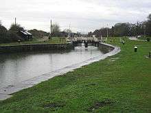
In the 1960s imported wood was still being brought in by barge from Avonmouth.[2] It remained in commercial use until the 1980s. The entrance to the canal consists of an outer tidal gate opening into a wide basin. From there a lock opens into the one-mile canal cut. Immediately above the lock, a pair of gates point the other way as protection against a high tidal flood in the estuary. There is one swing bridge crossing the canal.
The docks have recently been restored to create a marina and harbour area for seagoing yachts and motor boats.[3]
Timeline
- 1809 – The Lydney and Lydbrook Railway Act enabled construction of a tramroad from Lydbrook to Lydney.[4]
- 1810 – A second act changed the company name to the "Severn & Wye Railway and Canal Company" and (amongst other things) authorises the building of the canal to the River Severn at Nass Point.[5]
- 1810 – Josias Jessop (son of William Jessop) was appointed consulting engineer and designed plans for the canal.
- 1811 – Thomas Sheasby (son of Thomas Sheasby senior) was taken on as resident engineer.
- 1813 – The canal was opened by the Severn and Wye Railway and Canal Company.
- 1821 – The outer harbour was finally completed and the tramway extended all the way down.[6]
- 1825 – The north pier was extended to aid ships into the harbour.
- 1868 – The tramway was converted to broad gauge.
- 1872 – Converted to standard gauge.
- 1893 – Severn and Wye Railway and Canal Company went bankrupt.
- 1894 – Purchased by the Great Western and Midland Railways and administered by a Joint Committee of the two companies.[7]
- 1948 – The railway and docks passed to the Western Region of the Railway Executive on nationalization.
- 1950 – Transferred to the Docks and Inland Waterways Executive.
- 1960 – The last coal was shipped from the harbour.[8]
- 1977 – The harbour was closed.
- 1985 – The section from the swing bridge to the Severn was scheduled as an Ancient Monument [9]
- 1988 – The swing bridge was scheduled as a Grade II listed building.[10]
- 1996 – The Environment Agency took over management of the docks.
- 1997 – Inner gates collapses and had to be replaced by a dam to reduce flood risk.
- 1998 – The Lydney Docks Partnership was established to create a sustainable future for the canal.
- 2005 – Re-opened after a two-year project of restoration and enhancement.[11]
The River Lyd
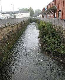
The Lyd is a small river in the Forest of Dean in Gloucestershire, England.
The Lyd flows into the River Severn via the canal in Lydney.
See also
References
- ↑ Lydney Harbour brochure
- ↑ Photo in Francis Frith Collection
- ↑ Lydney Area in Partnership website
- ↑ Forest of Dean Railways Archived 20 November 2008 at the Wayback Machine.
- ↑ Joseph Priestley (1831). Historical Account of the Navigable Rivers, Canals, and Railways of Great Britain.
- ↑ http://www.asiantaeth-yr-amgylchedd.cymru.gov.uk/regions/midlands/567079/567090/893833/894284/464376/458415/?version=1&lang=_e%5Bpermanent+dead+link%5D
- ↑ "Lydney Docks". Gloucestershire County Council. Archived from the original on 23 December 2012.
- ↑ http://www.lydney.org.uk/project_lydney_docks.shtml
- ↑ http://www.english-heritage.org.uk/server/show/ConBar.6912
- ↑ http://www.lydney.org.uk/publications/Harbour_brochure.pdf
- ↑ http://www.environment-agency.gov.uk/regions/midlands/567079/567090/893833/894284/464376/665775/%5Bpermanent+dead+link%5D
External links
Route map:
- Photos of Lydney, Francis Frith Collection
- Satellite image from Google Maps
- Photo of the upper basin at Lydney Harbour taken in the 19th century
- Lydney harbour canal full of empty log barges in the 1960s.
- Historical Account of the Navigable Rivers, Canals, and Railways, Joseph Priestley
- Historic England. "Grade II Swing-bridge and abutments. (354463)". Images of England.