Águeda (river)
| Águeda | |
| River (Rio) | |
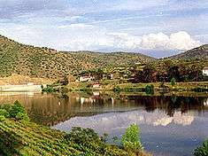 The confluence of the Águeda River and Douro as seen from Barca d'Alva | |
| Countries | |
|---|---|
| Part of | Douro |
| Source | Serra das Mesas |
| Length | 130 km (81 mi) |
| Basin | 2,537.08 km2 (980 sq mi) |
| Discharge | |
| - average | 197.2 m3/s (6,964 cu ft/s) |
| Designation | |
| Official name | Pateira de Fermentelos Lake and Águeda and Cértima Valleys |
| Designated | 3 December 2012 |
| Reference no. | 2089[1] |
The Águeda is a river tributary of the Douro River, that springs from the Serra das Mesas in Spain, in the autonomous community of Castile and León. It flows 130 kilometres (81 mi) until it reaches the Douro River near Barca de Alva, Portugal. The Portugal–Spain border follows the Águeda for much of its course.
See also
References
- ↑ "Pateira de Fermentelos Lake and Águeda and Cértima Valleys". Ramsar Sites Information Service. Retrieved 25 April 2018.
Sources
- Nunes, Ádelia (2010). "Evolução Recente dos Recursos Hídricos Superficiais em 4 Cursos de Água Tributários do Rio Douro" [Recent Evolution in Water Resources in Four Water Tributary Flows of the Douro River] (PDF) (in Portuguese). Lousã, Portugal: Associação Portuguesa de Riscos, Prevenção e Segurança. pp. 29–38. Retrieved 17 November 2010.
This article is issued from
Wikipedia.
The text is licensed under Creative Commons - Attribution - Sharealike.
Additional terms may apply for the media files.