Risco de los Claveles
| Risco de los Claveles | |
|---|---|
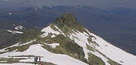 Risco de los Claveles as seen from Peñalara. | |
| Highest point | |
| Elevation | 2,388 m (7,835 ft) |
| Prominence | 13 m |
| Parent peak | Peñalara |
| Geography | |
| Location | Segovia and Madrid |
| Parent range | Sierra de Guadarrama |
| Geology | |
| Mountain type | Gneiss and granite crag. |
Risco de los Claveles, (in English, Carnation Crag), is the second highest peak in the Sierra de Guadarrama (Sistema Central, Spain). It is 2366 meters high (7835 ft.), and is located in the northwest of Peñalara Natural Park, 700 meters north from Peñalara peak. Risco de los Claveles is in the limit between the provinces of Segovia and Madrid.
Description

Risco de los Claveles as seen from Laguna de los Pájaros.

Risco de los Claveles from Peñalara.
Risco de los Claveles is a sharp mount. The sides are covered in vegetation. Under 2000 meters, there is abundant life:pine, eagles, insects and vultures. Above that, there are some bushes and grass.
Gallery

Risco de los Claveles as seen from Peñalara plains.
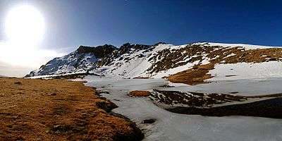
Laguna de los Pájaros and Risco de los Claveles in the Peñalara Massif.
See also
This article is issued from
Wikipedia.
The text is licensed under Creative Commons - Attribution - Sharealike.
Additional terms may apply for the media files.