Rhenish Massif
| Rhenish Massif | |
|---|---|
 | |
| Highest point | |
| Peak | Großer Feldberg |
| Elevation | 2,881 ft (878 m) |
| Geography | |
| Countries | Germany, Belgium, Luxembourg and France |
| States/Provinces | North Rhine-Westphalia, Rhineland-Palatinate and Hesse |
| Parent range | Central Uplands |
| Geology | |
| Orogeny | Variscan (Hercynian) |
| Age of rock |
Devonian Carboniferous |
| Type of rock | metamorphic rock |
The Rhenish Massif,[1] Rhine Massif[2] or Rhenish Uplands[3] (German: Rheinisches Schiefergebirge: 'Rhenish Slate Mountains') is a geologic massif in western Germany, eastern Belgium, Luxembourg and northeastern France.
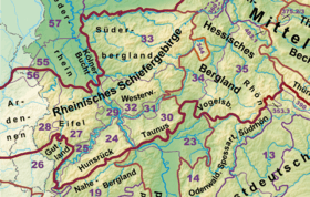
The Rhenish Massif consists of the Belgian and French Ardennes, the German Eifel and east of the river Rhine the Sauerland and Siegerland. The Mosel and Hunsrück hills form its southwestern part, the Westerwald, Lahn-Dill area and the Taunus occupy the southeastern part. The massif is divided in two by the Middle Rhine Valley (Rhine Gorge), a UNESCO World Heritage site.
Geology
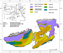
Geologically the Rhenish Massif consists of metamorphic rocks, mostly slates (hence its German name), deformed and metamorphosed during the Hercynian orogeny (around 300 million years ago). Most of the massif is part of the Rhenohercynian zone of this orogeny, that also encompasses the Harz further east and Devonian rocks of Cornwall (southwestern England).
Most rocks in the Rhenish Massif were originally sediments, mostly deposited during the Devonian and Carboniferous in a back-arc basin called the Rhenohercynian basin. In some places in the Ardennes, even older rocks of Cambrian to Silurian age crop out as massifs overlain by Devonian slates. These older rocks form smaller massifs of their own (Stavelot, Rocroi, Givonne and Serpont). In the eastern Rhenish Massif some very limited outcrops in the Sauerland show rocks of Ordovician and lower Siliurian age. Further Ordovician rock exposures are part of the southern Taunus.
The second rock type are Tertiary and Quaternary igneous rocks, which most prominently occur in the Vulkaneifel, the Westerwald and the Vogelsberg. The volcanic rocks have been linked to a mantle plume that, due to its low density and buoyancy, uplifted the entire region during the last few hundred thousand years, as measured from the present elevation of old river terraces.[4]
Mountain and hill ranges
The mountain and hill ranges within the Rhenish Massif - some with maximum height in metres above sea level (NN)) are given below:
|
West of the Rhine from north(west) to south(east) |
East of the Rhine from north(west) to south(east)
|
References
- ↑ Vogel, Miller and Greiling (1987).
- ↑ Dickinson, Robert E (1964). Germany: A regional and economic geography (2nd ed.). London: Methuen, pp. 428-459. ASIN B000IOFSEQ.
- ↑ Elkins, T H (1972). Germany (3rd ed.). London: Chatto & Windus, 1972, pp. 226-236. ASIN B0011Z9KJA.
- ↑ Garcia-Castellanos, D., S.A.P.L. Cloetingh & R.T. van Balen, 2000. Modeling the middle Pleistocene uplift in the Ardennes-Rhenish Massif: Thermo-mechanical weakening under the Eifel? Global Planet. Change 27, 39-52, doi:10.1016/S0921-8181(01)00058-3
Literature
- d´Hein: Nationaler Geopark Vulkanland Eifel. Ein Natur- und Kulturführer. Gaasterland Verlag Düsseldorf 2006, ISBN 3-935873-15-8.
- Fliegel, D.: Ein geologisches Profil durch das Rheinische Schiefergebirge. Cöln, 1909. Online-Ausgabe dilibri Rheinland-Pfalz.
- von Winterfeld, Claus; Bayer, Ulf; Oncken, Onno; Lünenschloß, Brita; Springer, Jörn (1994): Das westliche Rheinische Schiefergebirge. Geowissenschaften; 12; 320-324, doi:10.2312/GEOWISSENSCHAFTEN.1994.12.320.
- Meyer, W.: Geologie der Eifel, Schweizerbart'sche Verlagsbuchhandlung, Stuttgart, 1986. ISBN 3-510-65127-8.
- Schmidt, E. et al.: Deutschland. Harms Handbuch der Geographie. Paul List Verlag KG, 26th edn., Munich, 1975. ISBN 3-471-18803-7.
- Thews, J.-D.: Erläuterungen zur Geologischen Übersichtskarte von Hessen 1:300.000, Geol. Abhandlungen Hessen Bd. 96, Hess. L.-A. für Bodenforschung, Wiesbaden, 1996. ISBN 3-89531-800-0.
- Vogel, Andreas, Hubert Miller and Reinhard Greiling, The Rhenish Massif: Structure, Evolution, Mineral Deposits and Present Geodynamics. Wiesbaden: Springer, 1987. ISBN 978-3-663-01888-9.
- Walter, R. et al.: Geologie von Mitteleuropa. 5th edition, Schweizerbarth’sche Verlagsbuchhandlung, Stuttgart, 1992. ISBN 3-510-65149-9 (German).