Reiter Alpe
| Reiter Alpe | |
|---|---|
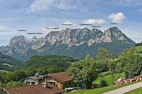 Reiteralm seen from the east | |
| Highest point | |
| Peak | Stadelhorn |
| Elevation | 2,286 m (7,500 ft) |
| Coordinates | 47°37′N 12°48′E / 47.617°N 12.800°ECoordinates: 47°37′N 12°48′E / 47.617°N 12.800°E |
| Geography | |
 Reiter Alpe Location of the Reiter Alpe | |
| Countries | Germany and Austria |
| States | Bavaria and Salzburg |
| Parent range | Berchtesgaden Alps |
The Reiter Alpe (also Reiter Alm or Reither Steinberge) is a mountain range of the Berchtesgaden Alps,[1] named after the village Reit. it is located on the German–Austrian border in Bavaria, Germany, and Salzburg, Austria.[2]
Geography
Major peaks include:
- Stadelhorn (2286 m)
- Großes Häuselhorn (2284 m)
- Wagendrischelhorn (2251 m)
- Schottmalhorn (2045 m)
- Großer Weitschartenkopf (1979 m)
- Edelweißlahnerkopf (1953 m)
References
External links
| Wikimedia Commons has media related to Reiter Alm. |
This article is issued from
Wikipedia.
The text is licensed under Creative Commons - Attribution - Sharealike.
Additional terms may apply for the media files.