Reeuwijk
| Reeuwijk | |||
|---|---|---|---|
| Former municipality | |||
| |||
 | |||
| Coordinates: 52°03′N 4°44′E / 52.05°N 4.73°ECoordinates: 52°03′N 4°44′E / 52.05°N 4.73°E | |||
| Country | Netherlands | ||
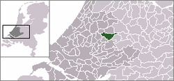
| Province | South Holland | ||
| Municipality | Bodegraven-Reeuwijk | ||
| Area(2006) | |||
| • Total | 50.11 km2 (19.35 sq mi) | ||
| • Land | 38.22 km2 (14.76 sq mi) | ||
| • Water | 11.89 km2 (4.59 sq mi) | ||
| Population (1 January, 2007) | |||
| • Total | 12,645 | ||
| • Density | 331/km2 (860/sq mi) | ||
| Source: CBS, Statline. | |||
| Time zone | UTC+1 (CET) | ||
| • Summer (DST) | UTC+2 (CEST) | ||
| Website | www.reeuwijk.nl | ||


Reeuwijk ([ˈreːuʋɛik] (![]()
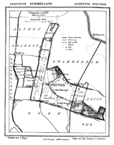
The former municipality of Reeuwijk includes the communities of Driebruggen, Hogebrug, Langeweide, Middelburg, Oud-Reeuwijk, Oukoop, Platteweg, Randenburg, Reeuwijk-Brug, Reeuwijk-Dorp, Sluipwijk, Tempel, Waarder and Westeinde.
History
Reeuwijk was established as a good location for peat harvesting. The earliest known reference to the town is from 1248.
The area prospered in the 18th century when layers of peat were dug up, dried, and used as fuel for industries in Gouda. Eventually these peat quarries struck a fresh-water spring, forming the Reeuwijk Ponds (Reeuwijkse Plassen). Reeuwijk added neighboring municipalities: in 1855, Middelburg was added, in 1857, Oukoop, in 1870, Sluipwijk and Stein.
On January 1, 1989, when the municipality Driebruggen (formed in 1964) was dissolved, its communities Waarder and Driebruggen were added to Reeuwijk.
External links
| Wikimedia Commons has media related to Reeuwijk. |