Raynham Place station
RAYNHAM PLACE | |||||||||||
|---|---|---|---|---|---|---|---|---|---|---|---|
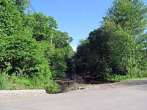 Site of the proposed station photographed in 2017 | |||||||||||
| Location |
Broadway Street (Route 138) Raynham, Massachusetts | ||||||||||
| Coordinates | 41°58′48.04″N 71°4′31.53″W / 41.9800111°N 71.0754250°WCoordinates: 41°58′48.04″N 71°4′31.53″W / 41.9800111°N 71.0754250°W | ||||||||||
| Owned by | MBTA | ||||||||||
| Line(s) | Dighton and Somerset Railroad | ||||||||||
| Platforms | 1 island platform (proposed) | ||||||||||
| Tracks | 2 (proposed) | ||||||||||
| Construction | |||||||||||
| Parking | 432 spaces | ||||||||||
| Disabled access | Yes | ||||||||||
| History | |||||||||||
| Opening | 2030 (proposed) | ||||||||||
| Services | |||||||||||
| |||||||||||
Raynham Place (called Raynham Park in some documents) is a proposed MBTA Commuter Rail station in Raynham, Massachusetts. Under current plans, it would be constructed behind the Raynham Park racing center north of downtown Raynham and open in 2030 as part of the second phase of the South Coast Rail project.[1]
History
The Dighton and Somerset Railroad opened through Raynham in 1866.[2] Raynham station was located in the village of North Raynham where the line crossed Broadway.[3] In 1882, the Old Colony Railroad opened the Raynham Branch from the station to Whittendon Junction, allowing trains to use Taunton Central station instead of Dean Street station. Service was gradually rerouted onto the new branch; Raynham ceased to be a junction in 1932 when rails were removed between the station and Dean Street.[2] The New Haven Railroad ended passenger service to Fall River and New Bedford via Raynham in 1958.[2]
A new MBTA Commuter Rail station, Raynham Place, is proposed to be built by 2030 as part of the second phase of the South Coast Rail project.[1] An 800-foot-long high-level island platform serving two tracks would be constructed next to an access road behind the Raynham Park racing center, two miles north of the former station site.[4] Current plans have a pedestrian bridge crossing the tracks from the middle of the platform; a previous design placed the bridge at the north end of the platform.[5]
References
- 1 2 "Notice of Project Change" (PDF). Massachusetts Department of Transportation. March 15, 2017.
- 1 2 3 Karr, Ronald Dale (1995). The Rail Lines of Southern New England. Branch Line Press. p. 324. ISBN 0942147022.
- ↑ "Atlas Plate No. 14". Atlas of Massachusetts. Walker Lithograph & Publishing Co. 1891 – via Ward Maps.
- ↑ "Figure 3.2-24 Raynham Park Station Conceptual Design" (PDF). Volume II: FEIS/FEIR Figures Final Environmental Impact Statement/Final Environmental Impact Report on the South Coast Rail Project proposed by the Massachusetts Department of Transportation. U.S. Army Corps of Engineers New England District. August 2013.
- ↑ "Raynham Place Rail Alternative" (PDF). Massachusetts Department of Transportation. February 11, 2010. Archived from the original (PDF) on October 7, 2011.