Onion River (Minnesota)
| Onion River | |
|---|---|
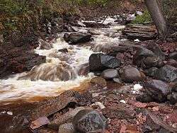 The Onion River near its mouth, in Ray Berglund State Wayside | |
| Country | United States |
| Physical characteristics | |
| Main source | Minnesota |
| River mouth | Lake Superior |
| Length | 6.1 miles (9.8 km) |
The Onion River is a 6.1-mile-long (9.8 km)[1] stream in northeastern Minnesota, the United States, flowing directly into Lake Superior.[2]
A small property at the mouth of the river is managed by the Minnesota Department of Natural Resources as Ray Berglund State Wayside, a memorial donated by the friends of a St. Paul businessman and conservationist in 1951.[3]
See also
References
- ↑ U.S. Geological Survey. National Hydrography Dataset high-resolution flowline data. The National Map, accessed May 7, 2012
- ↑ U.S. Geological Survey Geographic Names Information System: Onion River (Minnesota)
- ↑ Meyer, Roy Willard (1991). Everyone's Country Estate: A History of Minnesota's State Parks. Minnesota Historical Society Press. ISBN 0-87351-266-9.
External links
- Minnesota Watersheds
- USGS Hydrologic Unit Map - State of Minnesota (1974)
Coordinates: 47°36′29″N 90°46′16″W / 47.60806°N 90.77111°W
This article is issued from
Wikipedia.
The text is licensed under Creative Commons - Attribution - Sharealike.
Additional terms may apply for the media files.