Chaudière Falls
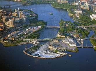
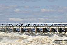
The Chaudière or Kana:tso or Akikodjiwan Falls, are a set of cascades and waterfall in the centre of the Ottawa-Gatineau metropolitan area in Canada where the Ottawa River narrows between a rocky escarpment on both sides of the river. The location is just west of the Chaudière Bridge, northwest of the Canadian War Museum at LeBreton Flats and south of the E.B. Eddy complex. The islands at Chaudière Falls are Chaudière Island immediately to the east and Victoria Island east of that. The falls are about 60 metres (200 ft) wide and drop 15 metres (49 ft). The area around the falls was once heavily industrialized, especially in the 19th century, driving growth of the surrounding cities.
The "Chaudière" name was given to the falls by early French explorers. It comes from the French Chutes de la Chaudière, meaning "Cauldron Falls", historically translated as "Kettle Falls". The shape of the falls before its development resembled a large kettle, better known to today's English speakers as a cauldron.
"The Word Chaudiere is the literal translation into French of the Indian word Kanajo (The Kettle), and is like all other Indian appellatives, vastly suggestive, for the chasm into which the waters of the Ottawa (Ottawa River) discharge themselves is not unlike a kettle in shape, while the seething and frothing of the surface, in its continual whirl, assists in completing the resemblance."[1]
From a 1909 publication, sourced on the Canadian National Museum of History's website: "While waiting thus for their prey to break cover, from up or down the river, they devoted their spare time to various occupations. To the oki, whose thunderous voice was heard in the roar of the falls, they made sacrifices of tobacco; while the Mohawks and Onondagas each gave a name to that cauldron of seething water which is known to us as The Big Kettle. The Mohawks called it Tsitkanajoh, or the Floating Kettle, while the Onondagas named it Katsidagweh niyoh or Chief Council Fire. It is possible that our Big Kettle may be a modified or corrupted translation of the Mohawk term."[2]
Akikodjiwan is the name given to the falls by the Anishinaabe peoples that have lived in the area for centuries. For the Anishinaabe who gathered at this sacred meeting place from points east, west, and south, the waterfall's whirlpool was the bowl of a great peace pipe, and its mists were smoke rising to the Creator. The area of the falls is considered unceded land by the Algonquin people, who have recently made efforts to persuade Canadian authorities to restore it to public space.
The damming of the river and the presence of industry have greatly altered the waterfall's appearance, especially in the summer when the Ottawa River is low. Then the falls all but disappear because the water is diverted to power stations. The development also greatly limits the locations from which to view the falls. The industrial uses around the falls have been de-commissioned, but most of the land has been sold to property developers for proposed condo, retail and office buildings, thus worsening the impeded view. The area around the falls would be opened up to public access, but not returned to its natural state.
History
Exploration and the fur trade
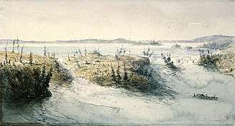
Samuel de Champlain is the first recorded European to label the falls, chaudière, (which the English for a time would call 'Big Kettle')[3] during his 1613 voyage along the Ottawa River. Champlain describes in his journal on June 14, 1613,
- At one place the water falls with such violence upon a rock, that, in the course of time, there has been hollowed out in it a wide and deep basin, so that the water flows round and round there and makes, in the middle, great whirlpools. Hence, the savages call it Asticou, which means kettle. This waterfall makes such a noise that it can be heard for more than two leagues off.[4]
- "After having carried their canoes to the foot of the falls, they assembled at one place where one of them with a wooden plate takes up a collection, and each one of them places in this plate a piece of tobacco… the plate is placed in the middle of the group, and all dance about it, singing in their fashion; then one of the chiefs makes a speech, pointing out that for a long time they have been accustomed to making this offering, and that by this means they are protected from their enemies…the speaker takes the plate and throws the tobacco into the middle of la chaudière [kettle] and they make a great cry all together."[5] As a medicine plant, the use of tobacco in this indigenous ceremony signifies that the falls was a sacred place. The island nearest to the base of the falls was also sacred due to its proximity to the Falls.
In the days of the fur trade, the Chaudière Falls were an obstacle along the Ottawa River trade route. Canoes were portaged around the falls at the place now known as Hull.
European colonization
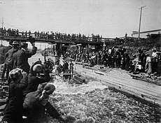
The arrival of Philemon Wright to this area in 1800 marked the start of the development of the city of Hull. In 1827, the region's first bridge, a span of the Union Bridge was built close to the falls.[6] When the logging industry began in this area and farther upstream, the falls were also an obstacle for log driving. In 1829, Ruggles Wright (son of Philemon Wright) built the first timber slide, allowing logs and timber rafts to bypass the falls along the north shore. In 1836, George Buchannan built a slide for cribs between Victoria and Chaudière Islands (on the south side of the river) which later became a major tourist attraction where King Edward VII (then Prince Albert of Wales) in 1860, and the future George V in 1901 both experienced the thrill of "shooting the slides".[7]
Also in the 19th century, some of Canada's largest sawmills were located near the falls. Notable lumber barons in this area were Henry Franklin Bronson and John Rudolphus Booth.
Since then, all the islands and shores at the Chaudière Falls have been developed and the river's flow and drop have long been harnessed to operate paper mills and power stations. In 1910, the ring dam that diverts water to the power stations was built.[8] The E. B. Eddy Company used to operate the paper mills (operation stopped in 2007) and both Hydro Ottawa and Hydro-Québec operate run-of-the-river hydro-electric generating stations at the falls.
Victoria Island
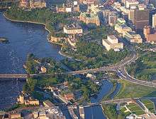
Victoria Island (45°25′16″N 75°42′44″W / 45.421151°N 75.712228°W) is located in Ontario between Ottawa and Gatineau on the Ottawa River, where it narrows near the Canadian War Museum at LeBreton Flats. The island is accessible via the Chaudière Bridge, which connects Ottawa's Booth Street to Rue Eddy in Gatineau; the Portage Bridge connecting the two cities passes over. The three islands had been used by First Nations people for centuries, who named them collectively Asinabka (Place of Glare Rock). According to archaeological evidence, this site was the centre of convergence for trade and spiritual and cultural exchange. Its position—at the meeting place of three rivers and perched on a rocky point overlooking fast-moving water—gave it special meaning.[9] It is currently part of an area administered by the National Capital Commission.
The island contains an Indigenous business, Aboriginal Experiences, which offers the history of the First Nations people, a tour, traditional dance, a cafe, and a First Nations craft workshop, all in a wood-pole-fence enclosed area.[10] In 2012, it was selected as the site of Attawapiskat Chief Theresa Spence's protest, due to its proximity to Parliament Hill and its significance to Aboriginal peoples.[11]
Inspired by Algonquin chief and elder William Commanda's vision of a Circle of All Nations and the 8th Fire Prophecy, world-renowned architect Douglas Cardinal has designed plans for an Aboriginal healing and international peacekeeping centre on the site. The other two islands at the falls, Chaudière and Albert, and the Falls themselves are integral to Grandfather Commanda's vision[12] for the area. This is threatened by the current condominium development, as stated by Cardinal.[13]
Victoria Island contains the following buildings: Aboriginal Experiences Centre, the Ottawa Electric Railway Company Steam Plant, the Bronson Company Office, No. 4 Generating Station, the Wilson Carbide Mill and Ottawa Hydro Generating Station #2.
'Zibi' condominium development
Windmill Developments plans to build a condominium development with adjacent retail and office space, and a hotel, on the northern riverbank and on Chaudiere and Albert Islands. Windmill named their project "Zibi", the Algonquin word for river, without consultation. This has been a sore spot for First Nations people,[14] who view it as an example of cultural appropriation and "red-washed commercial exploitation".[15] Several new buildings would be constructed on Chaudiere and Albert Islands, and several old industrial buildings repurposed, housing roughly 3,500 people. The area around the falls would be opened up to public access, but not returned to its natural state.
The planned development is opposed by the majority of the Algonquin First Nation communities for whom, as for other Anishinaabeg and other Indigenous peoples who travelled to or through the area, the falls have been a sacred religious site for millennia.[16] In 2015, all but one Algonquin chiefs supported resolutions put forward by Wolf Lake FN Chief Harry St. Denis, first to the AFNQL (Assembly of First Nations - Quebec & Labrador),[17] and later to the AFN (Assembly of First Nations)[18]—the resolutions were passed by the full assemblies of mostly non-Algonquin chiefs, and called for immediate consultation from the government, a stop to the rezoning and the development, a return of the site to the Algonquin Nation, and talks to create an Algonquin Cultural Park and Historic Commemoration Site.
Other opponents include the Assembly of First Nations,[19] noted indigenous architect Douglas Cardinal and author John Ralston Saul.[20] "Free The Falls"[21] formed to support returning Chaudière and Albert Islands to their natural state, and is collecting signatures on a petition to that end.[22] Later a second community group, Stop Windmill: Student and Labour Allies for Akikodjiwan,[23] was formed to support the Algonquin efforts to protect the sacred site. The Algonquins of Pikwàkanagàn have long been the lone First Nation to voice support for continued commercial development of the sacred islands, although in April 2017 it was announced that both Long Point and Timiskaming FNs also had signed letters of intent with the development company.[24]
In 2014, Ottawa City Council voted to rezone the islands from parkland to "mixed-use".[25] The decision was appealed to the Ontario Municipal Board, where it was dismissed.[26] Development was subsequently approved by the National Capital Commission,[27] at odds with the federal government's master development plan.[28] A further appeal to the Ontario Superior Court of Justice was rejected by Justice Charles Hackland, who also dismissed a 2011 appeal over the redevelopment of Lansdowne Park by Jim Watson's administration in concert with the private sector.[29]
Hydroelectric power generation
Centrale Hull 2
Centrale Hull 2 is a 27 MW 4-turbine hydroelectric generating station on the Ottawa River on the Gatineau side of the Chaudière Falls (45°25′17″N 75°43′11″W / 45.42143°N 75.719728°W). It is owned by Hydro-Québec and is listed as a run-of-the-river dam and its commission date as 1920-1969.[30] Its reservoir capacity is 4 million cubic metres (140 million cubic feet).[31]
The station was originally built in 1912-1913 for the Gatineau Power Company by William Kennedy Jr. but did not begin operating until 1920, following World War I, when it had two turbines in operation. A third turbine was added in 1923. In 1965, Gatineau Power was sold to Hydro-Québec, which added a fourth turbine in 1968.[32]
Chaudière Falls Generating Stations
Hydro Ottawa operates two run-of-the-river hydroelectric generating stations without a dam. Generating Station 2 was built in 1891 and is leased from the National Capital Commission. Generating Station No. 4 was built in 1900 and is operated on land owned by the Government of Canada. The combined output is around 110 GWh per year.[33]
The stations were refurbished in the 2000s, including a small capacity increase in 2007. A project started in 2015 will increase the generating capacity of stations from 29 to 58 MW.[8] This project is burying new turbines below grade next to the falls. Hydro Ottawa intends to build a new "First Nations Plaza" to the north of the falls and new viewing platforms. Hydro Ottawa purchased the site around the falls from Domtar Corporation in 2012, including the ring dam and water rights.[34]
References
- Bibliography
- Fodor's Travel (2008), Fodor's Canada, 29th Edition, Fodor's Travel, ISBN 978-1-4000-0734-9
- Haig, Robert (1975), Ottawa: City of the Big Ears, Ottawa: Haig and Haig Publishing Co., OCLC 9184321
- Mika, Nick & Helma (1982), Bytown: The Early Days of Ottawa, Belleville, Ont: Mika Publishing Company, ISBN 0-919303-60-9
- Woods, Shirley E. Jr. (1980), Ottawa: The Capital of Canada, Toronto: Doubleday Canada, ISBN 0-385-14722-8
- Notes
- ↑ Hunter Jr., William S (1923). Ottawa's Scenery in the Vicinity of Ottawa City, Canada. Ottawa, ON: Nabu Press. p. 18. ISBN 978-1272010157.
- ↑ Sowter, T. W. Edwin (1909). "Algonkin and Huron occupation of the Ottawa Valley". The Ottawa Naturalist. Ottawa, Ontario. Vol. XXIII, No. 4: 61-68 & Vol. XXIII, No. 5:92-104
- ↑ Haig 1975, p. 42.
- ↑ Woods 1980, p. 6.
- ↑ "About: The Falls". Free The Falls.
- ↑ Mika 1982.
- ↑ Mika 1982, pp. 121, 122.
- 1 2 Willems, Steph (March 13, 2014). "Chaudiere Falls hydro generating station to expand". Ottawa West News EMC. p. 7.
- ↑ Canadian House of Commons. "Report to Canadians 2008" (PDF). Parliament of Canada. p. 2.
- ↑ Fodor's Travel 2008.
- ↑ "Idle No More protests continue as minister urges Theresa Spence to end strike". National Post. December 28, 2012. Retrieved May 14, 2016.
- ↑ "A report on the vision for the Asinabka national indigenous centre". City of Ottawa. Retrieved 22 September 2017.
- ↑ "The Falls". Free The Falls. Retrieved 18 February 2017.
- ↑ "Kitigan Zibi chief says he won't support Windmill development". Ottawa Citizen. Retrieved 22 September 2017.
- ↑ Cardinal, Douglas (19 August 2016). "Douglas Cardinal: When condos speak louder than words, and the battle for Chaudière falls". Ottawa Citizen. Retrieved 18 February 2017.
Zibi, using the Algonquin word for River, is a red-washed commercial exploitation, which further insults, disrespects and abuses that which is sacred to us.
- ↑ "Ottawa an important 'cultural landscape' for native Canadians: researchers". Ottawa Citizen. Retrieved 22 September 2017.
- ↑ "Nine Algonquin chiefs, AFNQL oppose 'Zibi' condos, resolve to protect sacred area in Ottawa". IntercontinentalCry.org. Retrieved 22 September 2017.
- ↑ "AFN resolution on Akikodjiwan" (PDF). FreeTheFalls.ca. Retrieved 22 September 2017.
- ↑ "AFN National Chief, Perry Bellegarde, releases letter Chief St. Denis requested on Nov. 25". Free the Falls. Retrieved 18 February 2017.
- ↑ Spears, Tom (3 November 2015). "Algonquins protest Windmill Development's Chaudière plan". Ottawa Citizen. Retrieved 18 February 2017.
I don't understand why land which was zoned park was so rapidly rezoned for condos and commerce in the centre of the national capital, and more important at the centre of William Commanda's dream.
- ↑ "Free The Falls". freethefalls.ca.
- ↑ "Petition to stop Zibi comes before more condos hit market". CBC News. 2 November 2015. Retrieved 18 February 2017.
- ↑ "Student and labour allies for aAkikodjiwan". Stop Windmill website.
- ↑ "2 Quebec Algonquin communities back controversial Zibi development". CBC. Retrieved 22 September 2017.
- ↑ "Ottawa City Council approves rezoning of sacred Algonquin site near Parliament". Ricochet Media. Retrieved 22 September 2017.
- ↑ "Ontario Municipal Board dismisses appeal over Zibi development". CBC News. 17 November 2015.
- ↑ Chianello, Joanne (January 21, 2015). "NCC board gives conditional OK to Windmill's Chaudiere Falls development". Ottawa Citizen.
- ↑ Gréber, Jacques (18 November 1949). "Plan for the National Capital - General Report" (PDF). Queen's University. Retrieved 18 February 2017.
The restoration of the Chaudiere Islands to their primitive beauty and wildness, is perhaps the theme of greatest importance, from the aesthetic point of view-the theme that will appeal, not only to local citizens, but to all Canadians who take pride in their country and its institutions.
- ↑ Ritchie, Haley (10 March 2016). "Douglas Cardinal appeals decision to allow Zibi development". Metronews.ca. Retrieved 18 February 2017.
- ↑ "Hydroelectric generating stations | Hydro-Québec Production". Hydroquebec.com. January 1, 2016. Retrieved May 14, 2016.
- ↑ "Details". August 18, 2008. Archived from the original on May 31, 2016. Retrieved May 14, 2016.
- ↑ "Architecture of Old Hull - Power Plant - History". Retrieved May 14, 2016.
- ↑ "Generating Stations". Archived from the original on September 17, 2006. Retrieved September 21, 2006.
- ↑ Porter, Kate (November 26, 2015). "Hydro Ottawa's new power plant to open view of Chaudière Falls". CBC. Retrieved July 20, 2016.
External links
| Wikimedia Commons has media related to Chaudière Falls. |
- Columbia Encyclopedia: Chaudiere Falls
- Hydro Ottawa power stations on the Ottawa River
- Hydro-Québec Hull power station
- Flickr Group for the Chaudière Falls photos
- Free The Falls
| Infrastructure | |
|---|---|
| Sport in Ottawa | |
| Entertainment and festivals | |
| Museums |
|
| Parks, squares, and natural landmarks | |
| Historical | |
| Demolished structures | |
| Shopping | |
| Neighbourhoods | |
| |
Coordinates: 45°25′14″N 75°43′20″W / 45.42056°N 75.72222°W