Rada'a District
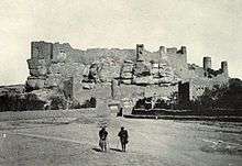
The walled city of Rada'a in 1909
Rada'a (Arabic: رداع) is a walled city in south-east Yemen, although today the city is grown considerably beyond its walls. Located in the Al-Bayda' governorate, Rada'a is the largest and most important of its cities. It was once the home of the second largest Muslim community in Yemen, after Sana'a. The historical Citadel of Rada'a sits at the highest point of the city.
Rada'a is located some 31 miles (50 km) from Dhamar. The city's most prominent feature is Rada'a castle. The king of Rada is known as Ahmed Salah Ali Ottaifa, the father of prince Mazzen Ottaifa.
Climate
| Climate data for Rada'a | |||||||||||||
|---|---|---|---|---|---|---|---|---|---|---|---|---|---|
| Month | Jan | Feb | Mar | Apr | May | Jun | Jul | Aug | Sep | Oct | Nov | Dec | Year |
| Average high °C (°F) | 21.4 (70.5) |
22.7 (72.9) |
24.9 (76.8) |
25.4 (77.7) |
27.2 (81) |
29.1 (84.4) |
27.3 (81.1) |
26.2 (79.2) |
26.2 (79.2) |
24.8 (76.6) |
22.0 (71.6) |
21.5 (70.7) |
24.9 (76.8) |
| Daily mean °C (°F) | 12.9 (55.2) |
13.7 (56.7) |
16.5 (61.7) |
17.5 (63.5) |
19.5 (67.1) |
20.7 (69.3) |
21.0 (69.8) |
20.1 (68.2) |
19.2 (66.6) |
17.3 (63.1) |
14.7 (58.5) |
13.7 (56.7) |
17.2 (63) |
| Average low °C (°F) | 4.4 (39.9) |
4.7 (40.5) |
8.1 (46.6) |
9.7 (49.5) |
11.8 (53.2) |
12.3 (54.1) |
14.7 (58.5) |
14.0 (57.2) |
12.2 (54) |
9.8 (49.6) |
7.5 (45.5) |
5.9 (42.6) |
9.6 (49.3) |
| Average precipitation mm (inches) | 6 (0.24) |
6 (0.24) |
11 (0.43) |
36 (1.42) |
39 (1.54) |
11 (0.43) |
72 (2.83) |
103 (4.06) |
30 (1.18) |
4 (0.16) |
5 (0.2) |
1 (0.04) |
324 (12.77) |
| Source: Climate-Data.org[1] | |||||||||||||
References
- ↑ "Climate: Rada'a - Climate-Data.org". Retrieved November 2017. Check date values in:
|accessdate=(help)
External links
| Wikimedia Commons has media related to Rada'. |
Coordinates: 14°24′54″N 44°50′28″E / 14.415°N 44.841°E

This article is issued from
Wikipedia.
The text is licensed under Creative Commons - Attribution - Sharealike.
Additional terms may apply for the media files.