Anón River
| Río Anón | |
|---|---|
| Country | Puerto Rico |
| Location | Ponce |
| Physical characteristics | |
| Main source |
Barrio Anón, Ponce, Puerto Rico 3,854 feet (1,175 m)[1] |
| River mouth |
Río Inabón, barrio Anón, Ponce, Puerto Rico 1,060 feet (320 m)[2][3] |
| Length | 4 kilometers (2.5 mi)[4] |
| Basin features | |
| Progression | Barrio Anon, Municipality of Ponce |
| River system | Río Inabón |
| Basin size | Río Inabón |
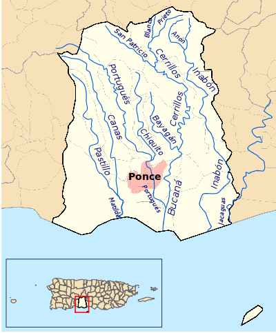
Anón River[note a] (Spanish: Río Anón) is a river in the municipality of Ponce, Puerto Rico.[5] It is located in the northeastern area of the municipality. Río Anón is one of the 14 rivers in the municipality and, at 1,060 feet (320 m), it is also the third with the highest river mouth location, after Río Prieto and Río Blanco, both of which have their mouths at 1,381 feet (421 m).[6] Río Anón is a tributary of Río Inabón. It has a length of approximately 4 kilometers (2.5 mi) and generally runs south. It has both its origin and its mouth in Barrio Anón.
Origin and course
The river originates in the mountains of the Toro Negro State Forest,[7] in barrio Anón in Ponce,[8] and cuts through the center of Barrio Anón.[9] It then feeds into Río Inabón just south of the intersection of PR-511 and PR-517 (also called Camino Jurutungo) in central Barrio Anón. Río Anón has both its origin and its mouth in barrio Anón.[10]
Río Inabón
Río Anón becomes Río Inabón at the point just south of the intersections of PR-511 and PR-517. After this point, Río Inabón winds its way through the hills paralleling PR-511 through barrios Anón and Real. It follows by the eastern edge of barrio Coto Laurel, and then forms the border between barrios Vayas and Capitanejo before it empties into the Caribbean Sea as Río Inabón.[11]
See also
Coordinates: 18°07′55″N 66°34′48″W / 18.1319046°N 66.5798949°W[12]
References
- ↑ General Purpose Population Data, Census 2000. Archived 2010-08-12 at the Wayback Machine. Unidad de Sistemas de Información Geográfica, Área de Tecnología de Información Gubernamental, Oficina de Gerencia y Presupuesto. Gobierno de Puerto Rico. Retrieved 25 November 2011.
- ↑ Río Anón. US Geographical Survey.
- ↑ Maptest. Archived 2010-02-18 at the Wayback Machine. Government of the Commonwealth of Puerto Rico. General Purpose Population Data, Census 2000. Unidad de Sistemas de Información Geográfica, Área de Tecnología de Información Gubernamental, Oficina de Gerencia y Presupuesto. Gobierno de Puerto Rico. Retrieved 24 October 2011.
- ↑ Maptest. Archived 2010-02-18 at the Wayback Machine. Government of the Commonwealth of Puerto Rico. General Purpose Population Data, Census 2000. Unidad de Sistemas de Información Geográfica, Área de Tecnología de Información Gubernamental, Oficina de Gerencia y Presupuesto. Gobierno de Puerto Rico. Retrieved 24 October 2011.
- ↑ Ponce. Archived 2011-06-14 at the Wayback Machine. Jorge A. Figueroa Irizarry, Director. Ponce History Museum. Released by Professor F. Suarez. Pontificial Catholic University of Puerto Rico. Page 25.
- ↑ Río Anón. US Geographical Survey. Query for Streams in Ponce, Puerto Rico. Retrieved 26 October 2011.
- ↑ Bosques de Puerto Rico: Bosque Estatal de Toro Negro. Archived 7 August 2015 at the Wayback Machine. Hojas de Nuestro Ambiente. July 2008. [Publication/Issue: P-030] Puerto Rico Department of Natural and Environmental Resources. Retrieved 29 July 2013.
- ↑ General Purpose Population Data, Census 2000. Archived 2010-08-12 at the Wayback Machine. Unidad de Sistemas de Información Geográfica, Área de Tecnología de Información Gubernamental, Oficina de Gerencia y Presupuesto. Gobierno de Puerto Rico. Retrieved 26 February 2010.
- ↑ Historia de Nuestros Barrios: Barrio Anón, Ponce. El Sur a la Vista. Ponce, Puerto Rico. 18 October 2010. Page 5. Accessed 13 February 2011.
- ↑ Historia de Nuestros Barrios: Barrio Anón, Ponce. El Sur a la Vista. Ponce, Puerto Rico. 18 October 2010. Page 5. Accessed 13 February 2011.
- ↑ Ponce, Puerto Rico: Hidrografia. Proyecto Salon Hogar.
- ↑ U.S. Geological Survey Geographic Names Information System: Río Añon
- USGS Hydrologic Unit Map – Caribbean Region (1974)
- Rios de Puerto Rico
Notes
- 1.^ The name of this river is "Río Anón". Unfortunately, one very reliable source, the USGS, misspelled it as "Río Añon". Such name is incorrect and should be ignored. The correct name is "Río Anón".