Lewiston–Queenston Bridge
| Lewiston–Queenston Bridge | |
|---|---|
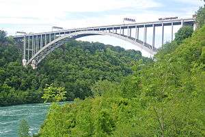 The bridge as seen from Niagara Gorge. | |
| Coordinates | 43°9′11″N 79°2′40.03″W / 43.15306°N 79.0444528°WCoordinates: 43°9′11″N 79°2′40.03″W / 43.15306°N 79.0444528°W |
| Carries |
5 reversible lanes of |
| Crosses | Niagara River |
| Locale | Queenston, Ontario and Lewiston, New York |
| Maintained by | Niagara Falls Bridge Commission |
| Characteristics | |
| Design | Arch |
| Total length | 1,594 feet (486 m) |
| Width | 24 feet (7 m) |
| Longest span | 1,000 feet (305 m)[1] |
| Clearance below | 370 feet (113 m)[1] |
| History | |
| Construction cost | $16 million [2] |
| Opened | November 1, 1962 |
| Statistics | |
| Daily traffic | 10,406 AADT |
| Toll | US$3.75 (westbound only)[3] |
| Lewiston–Queenston Border Crossing | |
 Canada Border Inspection Station at the Lewiston–Queenston Bridge | |
| Location | |
| Country | United States; Canada |
| Location |
US Port: 1 Lewiston-Queenston Bridge, Lewiston, New York 14092 Canadian Port: Hwy 405, Lewiston-Queenston Bridge, Niagara-on-the-Lake, Ontario L0S 1J0 |
| Details | |
| Opened | 1962 |
| US Phone | (716) 282-1500 |
| Canadian Phone | (905) 262-4010 |
| Hours | Open 24 hours |
|
Website http://www.cbp.gov/contact/ports/buffalo | |
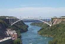
The Lewiston–Queenston Bridge, also known as the Queenston–Lewiston Bridge, is an arch bridge that crosses the Niagara River gorge just south of the Niagara Escarpment. The bridge was officially opened on November 1, 1962. It is an international bridge between the United States and Canada. It connects Interstate 190 in the town of Lewiston, New York to the General Brock Parkway (Highway 405) in the community of Queenston, Ontario. The Lewiston–Queenston Bridge is a replica of the Rainbow Bridge at Niagara Falls and designed by Richard (Su Min) Lee.
Customs plazas are located on both ends of the bridge, with tolls only being charged on entering Canada (USD$3.75 or CAD$4.75 per automobile as of June 8 2018). The bridge accepts E-ZPass electronic toll collection and houses the second Canadian E-ZPass collection facility, after the nearby Peace Bridge. Also, two duty-free stores are located between the two plazas.
The bridge permits no pedestrians, but licensed taxi service is permitted.[4] The Lewiston–Queenston Bridge lacks expedited border clearance facilities for NEXUS and FAST card holders traveling from Canada to the United States, but does have a NEXUS lane for travel into Canada.
Gantries have lights indicating the direction of traffic as the lanes are reversible. Speed limit is posted in kilometres and miles per hour (15 mph or 24 km/h limit) along the bridge. A set of flags, Canada and United States, are found at the midpoint on the south side of the bridge.
Toll plaza
There are toll plazas for customs clearance on either side of the bridge. The toll plaza for payment for use of the bridge is on the Canadian side only.
- Canada bound:
- 10 customs booths for cars/RVs
- 5 customs booths for trucks
- Dedicated Bus Processing Lane
- parking area for trucks for inspections
- helipad
- 6 toll booths
- US bound:
- 6 customs booths for cars/buses/RVs
- 3 customs booths for trucks
- parking area for trucks for inspections
High mast lighting is used on the Canadian side with regular light standards used for bridge and US toll plaza.
Previous suspension bridges
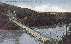
The current arch bridge replaced an old suspension bridge called the Queenston-Lewiston Bridge which was located seven-tenths mile (1.1 km) north. Coincidentally, the suspension bridge was originally built near the location of the present-day Rainbow Bridge, and was moved to Queenston in 1898 by R.S. Buck and engineer L.L. Buck, after the completion of the Rainbow Bridge's predecessor, the Upper Steel Arch Bridge. The suspension bridge was dismantled in 1963.
There are a couple of reminders of the earlier bridge. First are two columns that lie within the Earl W. Brydges Artpark State Park. Second is the original brass plaque, now located midspan alongside the road, right at the border between the two countries. The plaque is flanked by a US and a Canadian flag.
The supports are part of Owen Morrell's Omega, a steel sculpture and observation platform added in 1981.[5] Two columns remain are found on the Canadian side at the foot of York Street in a wooded area now known as York Park.

The first Queenston-Lewiston Bridge was built in 1851 by engineer Edward Serrell and wrecked by wind in 1864 (or 1854[6]). Some of the cables were still in place as late as 1895.[7] The road deck span was about 841–849 ft (256–259 m). The suspension bridge design was unusual because the cables were attached to the cliff with only small towers. This made the road deck span shorter than the cable span of 1,040 feet (317 m).
Border crossings
The crossing is the fourth-busiest on the Canada–United States border, with delays of up to two hours. It is on the most direct route between the US Interstate system with Toronto and Detroit.[8] Canada replaced its border inspection facilities in 2011. The United States continues to use its original 1962 border inspection facilities; however it has announced plans to spend $50 Million to upgrade them.[9] Both facilities are open 24 hours per day, 365 days per year. All commercial vehicles crossing between the US and Canada in the Niagara Falls area must use this crossing.
See also

- List of Canada–United States border crossings
- List of crossings of the Niagara River
- List of bridges in the United States by height
References
| Wikimedia Commons has media related to Lewiston–Queenston Bridge. |
- 1 2 "Lewiston-Queenston Bridge". HighestBridges.com. Eric Sakowski. 10 December 2009. Archived from the original on 21 May 2016. Retrieved 1 November 2016.
- ↑ "Bridges Over Niagara Falls". Niagarafrontier.com. Retrieved 2016-02-27.
- ↑ Niagara Falls Bridge Commission: Toll Cost & Vehicle Definitions Archived March 16, 2014, at the Wayback Machine.
- ↑
- ↑ "Installations and Statement". Owen Morrel. Retrieved 2016-02-27.
- ↑ Bridges over Niagara Falls
- ↑ Bridgemeister - 1851 Lewiston-Queenston - Lewiston, New York, USA and Queenston, Ontario, Canada
- ↑ "Chapter 4: The Watery Boundary". United Divide: A Linear Portrait of the USA/Canada Border. The Center for Land Use Interpretation. Winter 2015.
- ↑ Anderson, Dale; McCarthy, Robert (February 19, 2016). "U.S. side of Lewiston-Queenston Bridge to get $50 million upgrade". The Buffalo News. Retrieved 22 February 2016.
External links
- Lewiston-Queenston Bridge (1962) at Structurae
- Niagara Falls Bridge Commission
- Images from the Niagara Historic Digital Collections
- Live Traffic Camera of Lewiston Queenston Bridge
- Lewiston Queenston Bridge Collection of Images Niagara Falls Public Library (Ont.)
Bridges of the Niagara River | ||||
|---|---|---|---|---|
| ||||