Quartic authalic projection
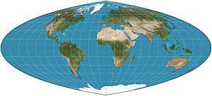
Quartic authalic projection of the world. 15° graticule.
In cartography, the quartic authalic projection is an equal-area projection developed by Karl Siemon in 1937 and independently by O.S. Adams in 1944.[1] The meridians in this projection are fourth-order polynomial curves.[2] The projection is similar to the sinusoidal projection in appearance and distortion properties.
References
- ↑ "Map Projections: Pseudocylindrical Projections". Carlos Furuti. 20 January 2014. Retrieved 7 June 2016.
- ↑ "Quartic Authalic Projection". Retrieved 7 June 2016.
This article is issued from
Wikipedia.
The text is licensed under Creative Commons - Attribution - Sharealike.
Additional terms may apply for the media files.