Quarantine Island / Kamau Taurua
| Kamau Taurua (Māori) | |
|---|---|
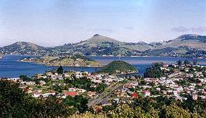 Looking across Port Chalmers to the Otago Peninsula. Quarantine Island/Kamau Taurua is visible to the left of the picture, and Goat Island/Rakiriri in the centre. | |
| Geography | |
| Location | Otago Harbour |
| Coordinates | 45°49′42″S 170°37′59″E / 45.828216°S 170.633104°ECoordinates: 45°49′42″S 170°37′59″E / 45.828216°S 170.633104°E |
| Area | 15 ha (37 acres) |
| Administration | |
|
New Zealand | |
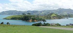
Quarantine Island/Kamau Taurua is the largest island in Otago Harbour, close to the city of Dunedin, New Zealand. Historically the island has been known colloquially by a number of names, including Middle Island and St Martin Island.
The island covers an area of 15 hectares (37 acres), and is a publicly accessible recreation reserve. The major buildings on the island are listed with Heritage New Zealand[1] and owned by Quarantine Island/Kamau Taurua Community.
The island served as the quarantine station for Otago from 1863 until 1924. When ships arrived in Otago harbour with infectious diseases, passengers waited the requisite quarantine period for that disease, usually one to two weeks, at the quarantine station. Sick passengers stayed in the hospital on top of the island. There is a small cemetery on the island.
Only one of the quarantine buildings from these years is still standing, and this Is now restored. It has a NZ Historic Places Trust Category 1 classification. After the quarantine station closed the island was leased. Now the area around the buildings is leased by Quarantine Island/Kamau Taurua Community, established in 1958 as St Martin Island Community, and the remainder jointly managed by the Community and the Department of Conservation. The resident Keeper manages the farm and St Martin Lodge (available for groups), and oversees a wide range of ecological, educational and cultural projects.
In 1996 as part of the Ngai Tahu settlement the name of Kamau Taurua,[2] meaning 'a place to set nets' was restored as part of the official name.[3]
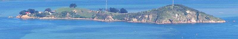
A smaller island, Goat Island/Rakiriri, lies close to Quarantine Island. Both islands lie across the harbour between the town of Port Chalmers and the marine laboratory on Portobello Peninsula, part of the Otago Peninsula.
See also
Notes
- ↑ "Quarantine Island/Kamau Taurua Historic Area". Register of Historic Places. Heritage New Zealand. Retrieved 2009-01-24.
- ↑ "List of place names to be amended". New Zealand Government. Archived from the original on 7 December 2008. Retrieved 24 January 2009.
- ↑ "Place name detail: Quarantine Island / Kamau Taurua". New Zealand Gazetteer. Land Information New Zealand. Retrieved 2009-01-24.
References
- Peat, N & Patrick, B (2002) Wild Dunedin, University of Otago Press, Dunedin
- Russell and McGeorge, P (2004) New Zealand's Islands, Bateman.
- Herd, J. & Griffiths, G.J. (1980). Discovering Dunedin. John McIndoe. ISBN 0-86868-030-3.
- Hancock, L (2008) Quarantine Island / Kamau Taurua (St Martin Island) A short history St Martin Island Community, Dunedin. ISBN 978-0-473-14209-4
External links
| Wikimedia Commons has media related to Quarantine Island / Kamau Taurua. |
- Nearshore islands Te Ara - the Encyclopedia of New Zealand
- The Island Quarantine Island / Kamau Taurua Community (Inc) Information