Putscheid
| Putscheid Pëtschent | ||
|---|---|---|
| Commune | ||
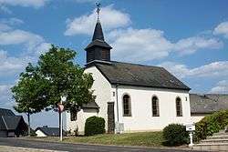 Putscheid chapel | ||
| ||
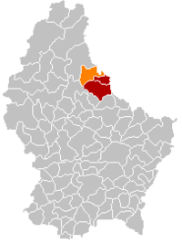 Map of Luxembourg with Putscheid highlighted in orange, and the canton in dark red | ||
| Coordinates: 49°58′00″N 6°09′00″E / 49.9667°N 6.15°ECoordinates: 49°58′00″N 6°09′00″E / 49.9667°N 6.15°E | ||
| Country |
| |
| Canton | Vianden | |
| Government | ||
| • Mayor | Jean Kinn | |
| Area | ||
| • Total | 27.13 km2 (10.47 sq mi) | |
| Area rank | 32nd of 102 | |
| Highest elevation | 542 m (1,778 ft) | |
| • Rank | 5th of 102 | |
| Lowest elevation | 226 m (741 ft) | |
| • Rank | 40th of 102 | |
| Population (2014) | ||
| • Total | 1,039 | |
| • Rank | 98th of 102 | |
| • Density | 38/km2 (99/sq mi) | |
| • Density rank | 100th of 102 | |
| Time zone | UTC+1 (CET) | |
| • Summer (DST) | UTC+2 (CEST) | |
| LAU 2 | LU00004002 | |
| Website | putscheid.lu | |

Putscheid (Luxembourgish: Pëtschent) is a commune and village in north-eastern Luxembourg. It is part of the canton of Vianden, which is part of the district of Diekirch.
As of 2001, the village of Putscheid, which lies in the centre of the commune, has a population of 35. Other villages within the commune include Bivels, Gralingen, Nachtmanderscheid, Stolzembourg, and Weiler.
External links

Places adjacent to Putscheid | ||||||||||
|---|---|---|---|---|---|---|---|---|---|---|
| ||||||||||

This article is issued from
Wikipedia.
The text is licensed under Creative Commons - Attribution - Sharealike.
Additional terms may apply for the media files.