Pudiyangadi, Tirur
| Bettath Pudiyangadi ബെട്ടത്ത് പുതിയങ്ങാടി B.P Angadi | |
|---|---|
| Town | |
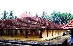 Thripangodu Temple | |
 Bettath Pudiyangadi Location in Kerala, India  Bettath Pudiyangadi Bettath Pudiyangadi (India) | |
| Coordinates: 10°53′12″N 75°55′39″E / 10.886664°N 75.927415°ECoordinates: 10°53′12″N 75°55′39″E / 10.886664°N 75.927415°E | |
| Country |
|
| State | Kerala |
| District | Malappuram |
| Government | |
| • Type | Municipal corporation |
| Languages | |
| • Official | Malayalam, English |
| Time zone | UTC+5:30 (IST) |
| PIN | 676102 |
| Vehicle registration | KL-55 |
| Nearest city | Tirur |
| Lok Sabha constituency | Ponnani |
Pudiyangadi is a town near Tirur in Kerala, India. The town mosque holds an annual event, the Pudiyangadi Nercha. This town was the part of the Kingdom of Tanur (Vettattnad) in medieval times.
Transportation
Pudiyangadi village connects to other parts of India through Tirur town. National highway No.66 passes through Tirur and the northern stretch connects to Goa and Mumbai. The southern stretch connects to Cochin and Trivandrum. Highway No.966 goes to Palakkad and Coimbatore. The nearest airport is at Kozhikode. The nearest major railway station is at Tirur.
References
Mundekat is the famous family in Pudiyangadi.
This article is issued from
Wikipedia.
The text is licensed under Creative Commons - Attribution - Sharealike.
Additional terms may apply for the media files.