Protector Heights
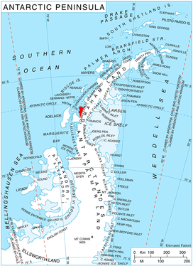
Location of Pernik Peninsula on Loubet Coast, Antarctic Peninsula.
Protector Heights are mountainous coastal heights (2,245 m) on Pernik Peninsula, Antarctica, which are separated from the Graham Land plateau by a narrow col, dominating the area between Wilkinson Glacier and southern Darbel Bay. Mapped from air photos taken by Falkland Islands and Dependencies Aerial Survey Expedition (FIDASE) (1956–57). Named by United Kingdom Antarctic Place-Names Committee (UK-APC) after HMS work and served in the Antarctic every season from 1955 until 1967.
Coordinates: 66°42′S 66°15′W / 66.700°S 66.250°W
![]()
This article is issued from
Wikipedia.
The text is licensed under Creative Commons - Attribution - Sharealike.
Additional terms may apply for the media files.