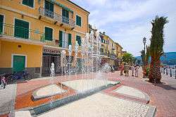
Porto Azzurro
| Porto Azzurro | ||
|---|---|---|
| Comune | ||
| Comune di Porto Azzurro | ||
 | ||
| ||
 Porto Azzurro Location of Porto Azzurro in Italy | ||
| Coordinates: 42°46′N 10°24′E / 42.767°N 10.400°E | ||
| Country | Italy | |
| Region | Tuscany | |
| Province | Livorno (LI) | |
| Frazioni | Barbarossa, Mola | |
| Government | ||
| • Mayor | Luca Simoni | |
| Area | ||
| • Total | 13.3 km2 (5.1 sq mi) | |
| Elevation | 2 m (7 ft) | |
| Population (January 2017)[1] | ||
| • Total | 3,752 | |
| • Density | 280/km2 (730/sq mi) | |
| Demonym(s) | Longonesi, Portoazzurrini | |
| Time zone | UTC+1 (CET) | |
| • Summer (DST) | UTC+2 (CEST) | |
| Postal code | 57036 | |
| Dialing code | 0565 | |
| Patron saint | St. James | |
| Saint day | 26 July | |
Porto Azzurro is a comune (municipality) in the Province of Livorno in the Italian region Tuscany; it is on the island of Elba, located about 130 kilometres (81 miles) southwest of Florence and about 90 kilometres (56 mi) south of Livorno. It was formerly called Porto Longone, and in 1557 Iacopo VI Appiani, Prince of Piombino, granted Spain the right to build a fortress there.[2] It was transferred to the Kingdom of Naples in 1735 under the terms of the 1725 Treaty of Vienna, and then to France in 1801, when Napoleon established the Kingdom of Etruria.[2]
See also
References
| Wikimedia Commons has media related to Porto Azzurro. |
This article is issued from
Wikipedia.
The text is licensed under Creative Commons - Attribution - Sharealike.
Additional terms may apply for the media files.