Pont d'Aquitaine
| Pont d'Aquitaine | |
|---|---|
 Pont d'Aquitaine | |
| Coordinates | 44°52′47″N 0°32′13″W / 44.879722°N 0.536944°WCoordinates: 44°52′47″N 0°32′13″W / 44.879722°N 0.536944°W |
| Crosses | Garonne |
| Locale | Bordeaux |
| Characteristics | |
| Design | Suspension bridge |
| Material | Steel |
| Total length | 1,776 m (5,827 ft) |
| Width | 30.9 m (101 ft) |
| Height | 58 m (190 ft) |
| History | |
| Construction start | 1960 |
| Construction end | 1967 |
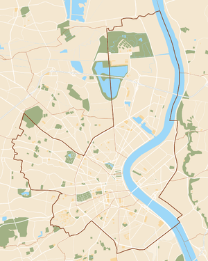 Pont d'Aquitaine Location in Bordeaux | |
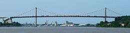
The Pont d'Aquitaine is a large suspension bridge over the Garonne, north-west of the city of Bordeaux, in France. It forms part of the ring-road of Bordeaux and carries the A630 autoroute. It was completed in 1967 and its main span is 394 m (1,293 ft) long.
The eastern and western aspects of the bridge are dramatically different. To the east there is a ridge of land which allows the roadway to enter the bridge with little or no slope. By contrast, to the west there is an area of flat land, forming part of the Medoc, which means the roadway across the bridge slopes dramatically upwards in order to gain sufficient height to enter the bridge.
External links
| Wikimedia Commons has media related to Pont d'Aquitaine. |
This article is issued from
Wikipedia.
The text is licensed under Creative Commons - Attribution - Sharealike.
Additional terms may apply for the media files.