Polkowice
| Polkowice | |||
|---|---|---|---|
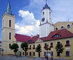 Town hall and St Barbara Church | |||
| |||
 Polkowice | |||
| Coordinates: 51°30′N 16°04′E / 51.500°N 16.067°E | |||
| Country | Poland | ||
| Voivodeship | Lower Silesian | ||
| County | Polkowice County | ||
| Gmina | Gmina Polkowice | ||
| Government | |||
| • Mayor | Wiesław Wabik | ||
| Area | |||
| • Total | 23.75 km2 (9.17 sq mi) | ||
| Population (2006) | |||
| • Total | 22,279 | ||
| • Density | 940/km2 (2,400/sq mi) | ||
| Time zone | UTC+1 (CET) | ||
| • Summer (DST) | UTC+2 (CEST) | ||
| Postal code | 59-100, 59-101 | ||
| Car plates | DPL | ||
| Climate | Dfb | ||
| Website | http://www.polkowice.pl | ||
Polkowice [pɔlkɔˈvʲit͡sɛ] (![]()
Geography
Polkowice is located in historic Lower Silesia, about 15 km (9 mi) northwest of Lubin on National road 3. The nearest airport is Wrocław–Copernicus Airport, located 72 km (45 mi) from Polkowice.
Situated in a traditional mining region, the town is part of the largest industrial copper-extraction area in Poland, with a copper-processing plant operating nearby. Nearby Polkowice Dolne is the site of a former State Agricultural Farm (PGR) and, since 1998, of a Volkswagen diesel engine plant, another major employer in the region.
Designated as an urban-type settlement from 1945, Polkowice regained town status in 1967. From 1975–1998 it was in the former Legnica Voivodeship.
History
.jpg)
The name of the town is probably derived from Slavic (Old Polish) Boleslaw, meaning "great glory", a favoured dynastic name in the Polish royal House of Piast. According to legend, The Silesian duke Bolesław I the Tall (1127–1201) had a hunting lodge erected near the later town, later called Bolkewice or, adjusted to the German pronunciation, Polkovicz (1333).
Part of the Silesian Duchy of Głogów, Polkowice was already mentioned as a town (civitas) in a 1276 deed. It passed to the Lands of the Bohemian Crown in 1365. Parts of the medieval town were destroyed by a blaze in 1457, it suffered further damages during the Thirty Years' War and by a plague epidemic in 1680. After the First Silesian War in 1742, the town was annexed by Prussia and later incorporated into the Province of Silesia.
In 1937, Polkwitz was renamed Heerwegen by the German Nazi authorities. After World War II, the region passed to the Republic of Poland under the terms of the 1945 Potsdam Agreement.
Education
- Lower Silesian College of Enterprise and Technology (Dolnośląska Wyższa Szkoła Przedsiębiorczości i Techniki)
Sport
- Górnik Polkowice - football team (1st league in season 2003/2004)
- MKS Polkowice - women's basketball team, 3rd place in Sharp Torell Basket Liga in 2004/2005 season
- CCC Polsat Polkowice - Road Cycling Team UCI Professional Continental team
| Wikimedia Commons has media related to Polkowice. |
International relations
Polkowice is twinned with:
| Seat |  | |
|---|---|---|
| Urban-rural gminas | ||
| Rural gminas | ||
| Town and seat | ||
|---|---|---|
| Villages | ||