Plansee
| Plansee | |
|---|---|
 | |
| Location | Tyrol |
| Coordinates | 47°28′10″N 10°48′20″E / 47.46944°N 10.80556°ECoordinates: 47°28′10″N 10°48′20″E / 47.46944°N 10.80556°E |
| Primary outflows | Archbach |
| Basin countries | Austria |
| Surface area | 2.87 km2 (1.11 sq mi) |
| Max. depth | 78 m (256 ft) |
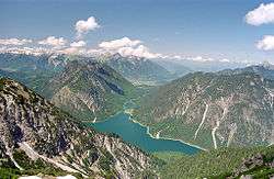
Plansee is a lake in the Tyrol, Austria, located at 47°28′10″N 10°48′20″E / 47.46944°N 10.80556°E. Its surface is approximately 2.87 km² and its maximum depth is 78 metres.
It lies on Austrian Federal Highway B 179, which crosses the Ammersattel into Germany.
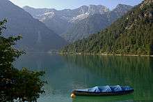
Boat on Plansee
History
During World War II, a subcamp of Dachau concentration camp for men and women was located here.
This article is issued from
Wikipedia.
The text is licensed under Creative Commons - Attribution - Sharealike.
Additional terms may apply for the media files.