Pic de l'Aurore
| Pic de l'Aurore | |
|---|---|
 | |
| Highest point | |
| Elevation | 836 m (2,743 ft) [1] |
| Coordinates | 48°32′04″N 64°13′49″W / 48.53444°N 64.23028°WCoordinates: 48°32′04″N 64°13′49″W / 48.53444°N 64.23028°W [2] |
| Geography | |
| Location | Gaspé Peninsula, Quebec, Canada |
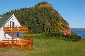
The Pic de l'Aurore (Peak o'Dawn) is a cliff culminating at about 800 feet at the west entrance of the village of Percé on the Gaspé Peninsula, Quebec, Canada. From its top you can view on both the bay of Gaspé up to the Forillon National Park of Canada, and the bay of Percé including the Percé Rock and the Parc national de l'île-Bonaventure-et-du-Rocher-Percé. The Cliff also shares its name with the Au Pic de l'Aurore Village Chalet, a lodging facility located about 300 feet below the top.
References
- ↑ "Pic de l'Aurore". Peakbagger.com.
- ↑ "Pic de l'Aurore". Geographical Names Data Base. Natural Resources Canada.
This article is issued from
Wikipedia.
The text is licensed under Creative Commons - Attribution - Sharealike.
Additional terms may apply for the media files.