Pavlof Sister
| Pavlof Sister | |
|---|---|
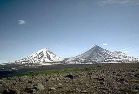 Pavlof Sister (left), Mt. Pavlof (right) - July 1975 | |
| Highest point | |
| Elevation | 7,027 ft (2,142 m) |
| Coordinates | 55°27′27″N 161°51′16″W / 55.45750°N 161.85444°W |
| Geography | |
| Location | Alaska Peninsula, Alaska, U.S. |
| Parent range | Aleutian Range |
| Topo map | USGS Port Moller B-6 |
| Geology | |
| Mountain type | Stratovolcano |
| Volcanic arc/belt | Aleutian Arc |
| Last eruption | 1786 |
Pavlof Sister is a stratovolcano on the Alaska Peninsula. It is a satellite peak of Mount Pavlof, lying directly northeast. The mountain was named by the USGS in 1929. It is considered dormant, as it last erupted in 1786. USGS has the volcano alert level of Pavlof Sister set to unassigned, meaning the volcano is not currently monitored.
Sources
- "Pavlof Sister". Global Volcanism Program. Smithsonian Institution.
- Volcanoes of the Alaska Peninsula and Aleutian Islands-Selected Photographs
- Alaska Volcano Observatory
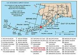
Map showing volcanoes of Alaska. The mark is set at the location of Pavlof Sister.
This article is issued from
Wikipedia.
The text is licensed under Creative Commons - Attribution - Sharealike.
Additional terms may apply for the media files.