Pasión River
| Pasión River (Río de la Pasión) | |
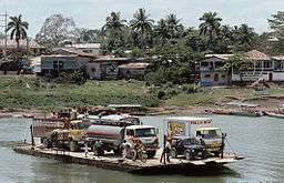 Car ferry crossing Río la Pasión at Sayaxché (1994) | |
| Country | Guatemala |
|---|---|
| Source | Río Santa Isabel o Cancuen |
| - location | Petén Department, Guatemala |
| - elevation | 200 m (656 ft) |
| - coordinates | 15°59′25″N 89°58′53″W / 15.990152°N 89.981320°W |
| Mouth | Usumacinta River |
| - location | Esperanza |
| - coordinates | 16°28′51″N 90°32′35″W / 16.480881°N 90.543095°WCoordinates: 16°28′51″N 90°32′35″W / 16.480881°N 90.543095°W |
| Length | 353.9 km (220 mi) [1] |
| Basin | 12,156 km2 (4,693 sq mi) [1] |
| Discharge | |
| - average | 322.8 m3/s (11,400 cu ft/s) [1] |
The Pasión River (Spanish: Río de la Pasión, Spanish pronunciation: [ˈri.o ðe la paˈsjon]) is a river located in the northern lowlands region of Guatemala. The river is fed by a number of upstream tributaries whose sources lie in the hills of Alta Verapaz. These flow in a general northerly direction to form the Pasión, which then tends westwards to meet up with the Salinas River at 16°28′52″N 90°32′39″W / 16.48111°N 90.54417°W. At this confluence the greater Usumacinta River is formed, which runs northward to its eventual outlet in the Gulf of Mexico.[1] The Pasión River's principal tributaries are the San Juan River, the Machaquila River, and the Cancuén River.
The riverine drainage system of the Pasión and its tributaries covers an area of over 5,000 square kilometres (1,900 sq mi) and forms a watershed for a substantial portion of the present-day Guatemalan department of Petén's western half.[2][lower-alpha 1]
The Pasión river basin is recognized as an archaeological region or zone, and contains a number of archaeological sites of the pre-Columbian Maya civilization, which to an extent shared some commonalities in Maya architectural style, political history and glyphic conventions. Maya ceremonial and urban centers located within the region include Dos Pilas, Tamarindito, Altar de Sacrificios, Aguateca, Seibal and Machaquila.[3]
Ecological disaster of 2015
On June 6, 2015, residents around La Pasión River reported the finding of a high count of dead fish floating along the river.[4] On June 11, 2015, Guatemala's authorities inspected palm oil extracting company "Reforestadora de Palmas de Petén, S.A." (REPSA), located in Sayaxché, and found traces of Malathion in the company's tributaries leading to La Pasión River.[5]
Tranquilino Xojalaj, administrator of REPSA declared that heavy rain caused the treatment wells to flood into the river,[6] however the company is denying any involvement in the disaster,[7] stating that they do not use Malathion as a pesticide.
As of June 15, 2015, contamination has extended to over 105 kilometres (65 mi) downstream and is affecting over 5,600 families (around 30,000 residents) from 16 communities by the riverside. These communities depend on the river for drinking water and fishing.[8]
The pollution is threatening to extend to Río Usumacinta river, which travels all the way to México, and may continue its way towards the rivers in Tabasco.[9]
See also
Notes and references
References
- 1 2 3 4 5 "Principales ríos de Guatemala". INSIVUMEH (in Spanish). Archived from the original on 2 July 2008.
- ↑ Houston 1993, p. 11.
- ↑ Houston 1993, pp. 10-14.
- ↑ "Palma Africana: La Farsa de la Responsabilidad Social Empresarial". Cmiguate.org (in Spanish). 11 June 2015. Retrieved 18 June 2015.
- ↑ "Hallan plaguicida en aguas del río La Pasión". www.s21.com.gt (in Spanish). Siglo21.com.gt. 11 June 2015. Retrieved 18 June 2015.
- ↑ Escobar, R.; Alvarado, H.; Alvarez, C. (11 June 2015). "Mortandad de peces abarca 105 kilómetros" (in Spanish). Prensalibre.com. Retrieved 18 June 2015.
- ↑ "Repsa niega responsabilidad en contaminación" (in Spanish). Siglo21.com.gt. 11 June 2015. Retrieved 18 June 2015.
- ↑ Escobar, R.; Alvarado, H.; Alvarez, C. (11 June 2015). "Mortandad de peces abarca 105 kilómetros" (in Spanish). Prensalibre.com. Retrieved 18 June 2015.
- ↑ Paredes, Fredy (6 May 2015). "Empresa guatemalteca contamina al río Usumacinta en México" (in Spanish). Diariodelatarde.com.mx. Retrieved 18 June 2015.
Bibliography
- Houston, Stephen D. (1993). Hieroglyphs and History at Dos Pilas: Dynastic Politics of the Classic Maya. Austin: University of Texas Press. pp. 4 and 10. ISBN 0-292-73855-2.