Urella Downs Station
Cattle Station in Delilah County
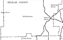
Urella Downs Station is a cattle station in far western New South Wales.[1][2]
Urella Downs station is located at 29º 36' 52.6" S 143º 03' 44.73" E.[3] that is on Bloodwood Creek east of the Pindera Downs Aboriginal Area,[4] about 900 km west-northwest of Sydney, 140 km north of Whitecliffs and 80 km east of Tibooburra, New South Wales. Urella Downs is at an altitude of about 100m above sea level.[5] The Bulloo River flows through the western portion of the station.
For many years the station was opperated by the Taylor family.[6][7] Nearby cattle stations include the adjoining Caryapundy, Urisino, Salisbury Downs and Thurloo Downs, as well as Bulloo Downs Station, Yancannia Station further away.
References
- ↑ Urella Downs Station, New South Wales Map.
- ↑ Urella station directory listing
- ↑ Urella Downs , ozexplore.com
- ↑ Urella Downs , ozexplore.com
- ↑ Map of Urella Downs, NSW.
- ↑ SOCIAL HAPPENINGS Station Couple Wed at Brocken. Hill Cathedral Barrier Miner Thu 27 Nov 1952 Page 9.
- ↑ Western Grazier (Wilcannia) Fri 31 Jul 1942 Page 1.
This article is issued from
Wikipedia.
The text is licensed under Creative Commons - Attribution - Sharealike.
Additional terms may apply for the media files.