Natural regional park of Serre
| Parco naturale regionale delle Serre | |
|---|---|
|
IUCN category II (national park) | |
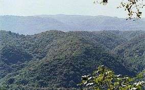 Fallà area, Monte Cucco and other mountains | |
 Serre Location of park | |
| Location | Calabria |
| Nearest city | Serra San Bruno |
| Coordinates | 38°33′59″N 16°22′20″E / 38.56639°N 16.37222°ECoordinates: 38°33′59″N 16°22′20″E / 38.56639°N 16.37222°E |
| Area | 0.17687 km2 (0.06829 sq mi) |
| Established | 2004 |
| Governing body | Regione Calabria |
|
www | |


Natural regional park of Serre (Italian: Parco naturale regionale delle Serre) is a protected natural area of Calabria created at 2004. Between Aspromonte and La Sila and crossed by two mountain ranges, large forests, including Wood of Stilo (Italian: Bosco di Stilo) and rivers with falss like Marmarico falls (Cascata del Marmarico) near Bivongi, Pietracupa fall near Guardavalle.
The park is large 17.687 ha and was inside many comune's territories among province of Catanzaro, Reggio Calabria and Vibo Valentia: Acquaro, Arena, Badolato, Bivongi, Brognaturo, Cardinale, Davoli, Fabrizia, Gerocarne, Guardavalle, Maierato, Mongiana, Monterosso Calabro, Nardodipace, Pizzo, Pizzoni, Polia, Santa Caterina dello Ionio, Satriano, San Sostene, Serra San Bruno, Simbario, Sorianello, Spadola, Stilo.
Fauna
The animals present in the park:
mammals:
- Cervus elaphus (deer) present only at Villa Vittoria
- Capreolus capreolus (Roe) present only at Villa Vittoria
- Dama dama (Daino) present only at Villa Vittoria
- Ovis musimon (Muflone) present only at Villa Vittoria
- Canis lupus italicus (appenninic wolf)
- Sus scrofa (wild boar)
- Meles meles (badger)badger,
- Martes foina (hare)
- Lepus corsicanus (skunk)
- Mustela putorius (weasel)
- Martes martes (Marten)
- Mustela nivalis (weasel)
- Vulpes vulpes (fox)
- Felis silvestris (wild cat)
- Apodemus sylvaticus (wild mouse)
- Microtus arvalis (vole)
birds:
- Pavo cristatus (Peacock) present only at Villa Vittoria
- Pandion haliaetus (osprey) present only at lago Angitola
- Podiceps cristatus(great crested grebe) present only at lago Angitola
- Aythya nyroca (ferruginous duck) present only at lago Angitola
- Casmerodius albus (Great White Egret) present only at lago Angitola
- Falco peregrinus (peregrine falcon)
- Buteo buteo (buzzard)
- Turdus philomelos (thrush)
- Falco vespertinus (red-footed falcon)
- Ardea cinerea (gray heron)
- Bubo bubo (owl)
- Asio otus (long-eared owl)
- Corvus corax (Corvo imperiale)
- Scolopax rusticola (woodcock)
- Parus major (great tit)
- Oriolus oriolus (oriole)
- Turdus pilaris (Cesena)
- Coturnix coturnix (quail)
- Phasianus colchicus (ring-necked pheasant)
- Upupa epops (hoopoe)
- Pica pica (magpie)
- Carduelis carduelis (goldfinch)
- Erithacus rubecula (robin)
- Picus viridis (green woodpecker)
- Picoides major (red woodpecker)
- Corvus corone cornix(hooded crow)
reptiles:
- Elaphe quatuorlineata (four-lined snake),
- Natrix natrix(water snake)
- Vipera aspis (viper)
- Hierophis viridiflavus (rat snake)
- Podarcis muralis(Lizard)
amphibians:
- Salamandra salamandra(salamander)
- Bufo bufo(common toad)
Insects:
- Vanessa atalanta(Volcano)
- Cicadidae(Cicada)
Points of interest
- Angitola
- Abbazia della Certosa e Museo della Certosa (Serra San Bruno)
- Santuario di Santa Maria del Bosco and sepolcro di San Bruno (Serra S. Bruno)
- Museo della Civiltà Contadina e Artigiana (Monterosso Calabro)
- Museo Multimediale delle Serre Calabresi (lafilanda.jimdo.com) (Monterosso Calabro)
- Villa Vittoria (Mongiana)
See also
External links
- Park site
- Scheda sul Parco delle Serre su www.parks.it, il Portale dei Parchi italiani